SPECIAL ANNOUNCEMENT |
 |
In partnership with Tri-City Performance, I'll be giving a free avalanche awareness presentation at their Centerville location on Tuesday, January 20th at 6:00. |
|
|
BOTTOM LINE
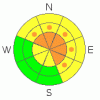
Danger by aspect and elevation on slopes approaching 35° or steeper.
(click HERE for tomorrow's danger rating)
|

Danger Rose Tutorial
|
At and above treeline the avalanche danger remains CONSIDERABLE today for triggering deep, dangerous avalanches which break into old snow near the ground. Human triggered avalanches are probable on slopes steeper than 35 degrees, especially those facing northwest, north, northeast, east and southeast which are steep and rocky with a shallow, weak underlying snowpack.
Mid elevations have a MODERATE avalanche danger on slopes steeper than 35 degrees facing the north half of the compass and human triggered avalanches are possible. Be aware- you can still trigger scary avalanches, especially in terrain where the snowpack is less than about 4' deep.
In wind sheltered terrain and on most south facing slopes at mid and low elevations the avalanche danger is generally LOW.
|
|
|
CURRENT CONDITIONS |

|
Another beautiful day is on tap in the mountains where the air is clear and temperatures warmer than most Salt Lake Valley locations. Currently at 10,000’ it’s 28 degrees, 23 degrees at the trailheads and 22 degrees in Salt Lake City. Southeasterly winds picked up around 3:00 this morning and are blowing 10-20 mph along the ridges, gusting into the low 30’s at the highest elevations. In between the old tracks and crusty snow, loud recycled powder can still be found on sheltered shady slopes.
|
|
|
RECENT ACTIVITY |

|
Friday, a snowmobiler remotely triggered a hard slab avalanche on a steep, northerly facing slope near Humpy Peak at about 10,500’ in elevation. The avalanche broke on weak snow near the ground taking out the entire seasons’ snowpack. Thanks to Bill DeLong for sending in pics and for all the great info!
For recent accident reports click here
For more photos of recent avalanche activity click here
|
|
|
THREAT #1 |

|
| WHERE |
PROBABILITY |
SIZE |
TREND |
|
|
|
|
| |
|
|
Over the next
24
hours.
|
|
|
I haven’t heard of any recent avalanche activity since Friday and you’d think eventually the snowpack would be on the mend and we could stop worrying about triggering avalanches to the ground. However, this year’s Uinta snowpack is different and my gut tells me we’re not out of the woods yet. Sure you can center punch bold lines and not trigger a slide and think you’re good to go and that’s just how the avalanche dragon lures you deeper into its den. Large, dangerous, hard slab avalanches can still be triggered, especially in steep rocky terrain with a shallow, weak snowpack. It doesn’t take a whole lot of snowpit analysis to figure this one out and fortunately you don’t have to be a snow or avalanche geek either. Look for and avoid steep slopes that have rocks or bushes poking through the snow, particularly if they’re connected to a slope that looks fat or feels really strong and dense.
|
|
|
THREAT #2 |

|
| WHERE |
PROBABILITY |
SIZE |
TREND |
|
|
|
|
| |
|
|
Over the next
24
hours.
|
|
|
You might be able to trigger an old wind slab or two, but in general they're few and far between and lack much punch. However, as always avoid any fat looking, hollow sounding pillow of snow. These are most prevalent on upper elevation, leeward slopes with an easterly component to their aspect. |
|
|
MOUNTAIN WEATHER |

|
Warm temperatures, sunny skies and light winds are on tap as high pressure remains camped out over the region through about midweek. Expect highs to reach near 50 degrees at 8,000’ and in the low to mid 40’s at 10,000’. Overnight lows dip into the mid to upper 20’s. Winds should remain pretty well-behaved, generally blowing out of the east and southeast, less than 20 mph. A midweek brush-by is slated, followed by a series of stronger systems arriving next weekend, giving us a better shot of measurable snowfall.
|
|
|
GENERAL ANNOUNCEMENTS |
Remember- your observations help to save other riders lives. So if you see or trigger any avalanches please let me know what your seeing. You can reach me at 801-231-2170 or craig@utahavalanchecenter.org
While it's quiet, now is a great time to schedule a free avalanche awareness class for your group or club. You can reach me at 801-231-2170 or craig@utahavalanchecenter.org for more details.
The information in this advisory expires 24 hours after the date and time posted. I'll update this advisory by 7:00 am on Wednesday Jan. 21, 2009. |
|
|
This information does not apply to developed ski areas or highways where avalanche control is normally done. This advisory is from the U.S.D.A. Forest Service, which is solely responsible for its content. This advisory describes general avalanche conditions and local variations always occur. |
|
This advisory provided by the USDA Forest Service, in partnership with:
The Friends of the Utah Avalanche Center, Utah Division of State Parks and Recreation, Utah Division of Emergency Management, Salt Lake County, Salt Lake Unified Fire Authority and the friends of the La Sal Avalanche Center. See our Sponsors Page for a complete list. |
