SPECIAL ANNOUNCEMENT |
 |
In partnership with Tri-City Performance, I'll be giving a free avalanche awareness presentation at their Centerville location on Tuesday, January 20th at 6:00. |
|
|
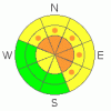
BOTTOM LINE
Danger by aspect and elevation on slopes approaching 35° or steeper.
(click HERE for tomorrow's danger rating)
|
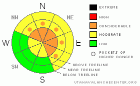
Danger Rose Tutorial
|
At and above treeline the avalanche danger remains CONSIDERABLE today for triggering deep, dangerous avalanches which break into old snow near the ground. Human triggered avalanches are probable on slopes steeper than 35 degrees, especially those facing northwest, north, northeast, east and southeast which are steep and rocky with a shallow weak underlying snowpack.
At mid elevations the avalanche danger is generally MODERATE on slopes steeper than 35 degrees facing the north half of the compass and human triggered avalanches are possible. Be aware- you can still trigger deep dangerous avalanches, especially in terrain where the snowpack is less than about 4' deep.
In wind sheltered terrain and on most south facing slopes at mid and low elevations the avalanche danger is generally LOW.
|
|
|
CURRENT CONDITIONS |

|
With high pressure firmly camped out over the region and temperature inversions starting to take hold, it’ll be another beautiful day in the mountains. Winds are light and northerly, blowing less than 15 mph along the ridges with a few gusts in the mid 20’s along the high peaks. Temperatures are in the upper 20’s at 10,000’, low 20’s at 8,000’ and Lily Lake reports 10 degrees. Despite the lack of recent snowfall, riding and turning conditions are quite good and recycled powder will be found on sheltered, shady, north facing slopes.
|
|
|
RECENT ACTIVITY |

|
Yesterday, a snowmobiler remotely triggered a hard slab avalanche on a steep, northerly facing slope near Humpy Peak at about 10,500’ in elevation. The avalanche broke on weak snow near the ground taking out the entire seasons’ snowpack. Thanks to Bill DeLong for sending in pics and for all the great info!
For recent accident reports click here
For more photos of recent avalanche activity click here
|
|
|
THREAT #1 |

|
| WHERE |
PROBABILITY |
SIZE |
TREND |
|
|
|
|
| |
|
|
Over the next
24
hours.
|
|
|
It’s been an active week along the eastern front beginning with several natural avalanches reported last Saturday and Sunday, a moose-alanche midweek and of course, yesterday’s human triggered avalanche. While the pattern remains complex and you can ride plenty of slopes and not trigger a slide, one thing is clear- avalanches are still being triggered on weak snow near the ground and the problem isn’t stabilizing at a rapid pace. As a matter of fact, persistent instabilities like our problem child the rain crust/weak, faceted snow interface are going to take some time to heal and we need to be patient. Don’t let the sunny skies and lack of avalanche activity lull you into a false sense of snow stability today. The avalanche dragon is alive and well in the western Uinta Mountains and deep dangerous avalanches can still be triggered especially on steep, mid and upper elevation slopes facing the north half of the compass.
|
|
|
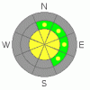
THREAT #2 |

|
| WHERE |
PROBABILITY |
SIZE |
TREND |
|
|
|
|
| |
|
|
Over the next
24
hours.
|
|
|
You might be able to trigger an old wind slab or two, but in general these are getting pretty tired and lack much punch... I'm starting to feel that way too. However, as always avoid any fat looking, hollow sounding pillow of snow. These are most prevalent on upper elevation, leeward slopes with an easterly component to their aspect.
|
|
|
MOUNTAIN WEATHER |

|
Sunny skies, light winds and warm temperatures are on tap through the weekend as high pressure homesteads over the region. Today, temperatures will reach into the low 40’s at 8,000’ and near freezing at 10,000’. Overnight lows dip into the low 20’s. Winds should remain fairly light, blowing in the 10-20 mph range even along the high ridges. ‘Bout the same weather is on tap for the region through midweek.
|
|
|
GENERAL ANNOUNCEMENTS |
Remember- your observations help to save other riders lives. So if you see or trigger any avalanches please let me know what your seeing. You can reach me at 801-231-2170 or craig@utahavalanchecenter.org
While it's quiet, now is a great time to schedule a free avalanche awareness class for your group or club. You can reach me at 801-231-2170 or craig@utahavalanchecenter.org for more details.
The information in this advisory expires 24 hours after the date and time posted. I'll update this advisory by 7:00 am on Sunday Jan. 18, 2009. |
|
|
This information does not apply to developed ski areas or highways where avalanche control is normally done. This advisory is from the U.S.D.A. Forest Service, which is solely responsible for its content. This advisory describes general avalanche conditions and local variations always occur. |
|
This advisory provided by the USDA Forest Service, in partnership with:
The Friends of the Utah Avalanche Center, Utah Division of State Parks and Recreation, Utah Division of Emergency Management, Salt Lake County, Salt Lake Unified Fire Authority and the friends of the La Sal Avalanche Center. See our Sponsors Page for a complete list. |
