SPECIAL ANNOUNCEMENT |
 |
In partnership with Tri-City Performance, I'll be giving a free avalanche awareness presentation at their Centerville location on Tuesday, January 20th at 6:00. |
|
|
BOTTOM LINE
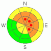
Danger by aspect and elevation on slopes approaching 35° or steeper.
(click HERE for tomorrow's danger rating)
|

Danger Rose Tutorial
|
At and above treeline the avalanche danger remains CONSIDERABLE today for triggering deep, dangerous avalanches which break into old snow near the ground. Human triggered avalanches are probable on slopes steeper than 35 degrees, especially those facing northwest, north, northeast, east and southeast. Within this terrain there are pockets of HIGH danger and human triggered avalanches are likely especially on steep rocky slopes with a shallow weak snowpack.
At mid elevations the avalanche danger is generally MODERATE on slopes steeper than 35 degrees facing the north half of the compass and human triggered avalanches are possible. Be aware- you can still trigger deep dangerous avalanches, especially in terrain where the snowpack is less than about 4' deep.
Out of the wind and on most south facing slopes at mid and low elevations the avalanche danger is generally LOW.
|
|
|
CURRENT CONDITIONS |

|
Skies have finally cleared as high pressure begins to take hold over the region. West and northwest winds are still an issue and have been blowing in the 15-35 mph range with gusts in the 50’s and 60’s along the high ridges since mid day Saturday. Temperatures are slightly inverted and it’s 22 degrees at 10,000’, 17 degrees at 8,000’. Winds damaged a lot of the upper elevation terrain, but good riding and turning conditions can still be found on wind sheltered, shady slopes.
|
|
|
RECENT ACTIVITY |

|
Several recent natural avalanches have been reported this week as a result of the strong winds. One occurred late Saturday near Mill Hollow, the other sometime Sunday in 1000 Peaks. Both are very large, wide and deep, running to the ground. Click here for photos.
The moose is loose! A sizeable animal triggered and survived another avalanche in the East Fork of the Bear River Drainage. This slide was 3’ deep, 150’ wide and ran 100’ vertically. The weak layer was facets above the now notorious Thanksgiving rain crust.
For recent accident reports click here
For more photos of recent avalanche activity click here
|
|
|
THREAT #1 |

|
| WHERE |
PROBABILITY |
SIZE |
TREND |
|
|
|
|
| |
|
|
Over the next
24
hours.
|
|
|
From natural slides to Moose-avalanches, it’s been a pretty active few days on the eastern front. While the weak layers of snow near the ground seem pretty unpredictable, one thing is for sure- each time they’re rapidly loaded we see big avalanches. Might sound kinda simple and reality it is, but determining which slope is going to slide to the ground is a crap shoot. The recent avalanche events are occurring in steep terrain which didn’t slide during the Christmas storm cycle and they’re taking out the entire seasons’ snowpack, piling up huge amounts of tree snapping, bone crushing debris. Though it’s getting harder to trigger these types of avalanches the outcome is devastatingly disastrous. Thin snowpack areas facing the north half of the compass which are steep and rocky continue to be likely suspects. |
|
|
THREAT #2 |

|
| WHERE |
PROBABILITY |
SIZE |
TREND |

|
|
|
|
| |
|
|
Over the next
24
hours.
|
|
|
Newly formed wind slabs are going to be stubborn and feel pretty glued in place. However, once triggered these could potentially initiate a deeper avalanche as they descend the slope. I’d continue avoiding any fat looking, hollow sounding pillows of snow and because the winds have been nuking, these formed lower down slope than unusual. |
|
|
MOUNTAIN WEATHER |

|
High pressure homesteads over the region through the weekend, giving us sunny skies and warming temperatures. Highs today at 8,000’ will reach into the mid 30’s and at 10,000’ in the upper 20’s. Overnight lows dip into the upper teens. Northwest winds should relax somewhat, averaging in the teens with gusts in the 30’s along the ridges. Looks like the weather pattern remains quiet through early next week. |
|
|
GENERAL ANNOUNCEMENTS |
Remember- your observations help to save other riders lives. So if you see or trigger any avalanches please let me know what your seeing. You can reach me at 801-231-2170 or craig@utahavalanchecenter.org
While it's quiet, now is a great time to schedule a free avalanche awareness class for your group or club. You can reach me at 801-231-2170 or craig@utahavalanchecenter.org for more details.
The information in this advisory expires 24 hours after the date and time posted. I'll update this advisory by 7:00 am on Saturday Jan. 17, 2009. |
|
|
This information does not apply to developed ski areas or highways where avalanche control is normally done. This advisory is from the U.S.D.A. Forest Service, which is solely responsible for its content. This advisory describes general avalanche conditions and local variations always occur. |
|
This advisory provided by the USDA Forest Service, in partnership with:
The Friends of the Utah Avalanche Center, Utah Division of State Parks and Recreation, Utah Division of Emergency Management, Salt Lake County, Salt Lake Unified Fire Authority and the friends of the La Sal Avalanche Center. See our Sponsors Page for a complete list. |
