SPECIAL ANNOUNCEMENT |
 |
In partnership with Plaza Cycle and Wasatch County Search and Rescue, I’ll be giving a free avalanche awareness presentation on Monday Jan. 12th at 7:00. The program will be held at the Search and Rescue building in Heber. Hope to see y’all there. |
|
|
BOTTOM LINE
Danger by aspect and elevation on slopes approaching 35° or steeper.
(click HERE for tomorrow's danger rating)
|
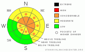
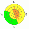
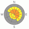
Danger Rose Tutorial
|
At and above treeline the avalanche danger is CONSIDERABLE today for both new and old wind slabs along with deeper, more dangerous avalanches which break into old snow near the ground. Human triggered avalanches are probable on slopes steeper than 35 degrees, especially those facing northwest, north, northeast, east and southeast.
At mid elevations the avalanche danger is generally MODERATE on slopes steeper than 35 degrees facing the north half of the compass and human triggered avalanches are possible. Be aware- you can still trigger deep dangerous avalanches, especially in terrain where the snowpack is less than about 4' deep.
Out of the wind and on most south facing slopes at mid and low elevations the avalanche danger is generally LOW.
|
|
|
CURRENT CONDITIONS |

|
High clouds are streaming through the region this morning as we remain in a somewhat moist northwest flow. The big news though is the west and northwest winds. They started cranking around noon yesterday and have been ruthless along the ridges, averaging 15-35 mph with gusts in the 60’s and 70’s along the high peaks. Temperatures are in the low to mid 20’s at both 8,000’ and 10,000’. Unfortunately, much of the upper elevation terrain is wind jacked and sun-exposed slopes probably have a slight zipper crust, but good creamy powder will still be found in sheltered, shady locations. |
|
|
RECENT ACTIVITY |

|
A large natural avalanche was spotted on Thursday above Camp Steiner at approx. 11,000 ft. and probably occurred after the Jan. 6th wind event. This avalanche was 8-10 ft. deep, 600-800 ft. wide, running 800 ft. vertical. Thanks Ted for scoping this one out!
For recent accident reports click here
For more photos of recent avalanche activity click here
|
|
|
THREAT #1 |

|
| WHERE |
PROBABILITY |
SIZE |
TREND |
|
|
|
|
| |
|
|
Over the next
24
hours.
|
|
|
Raging upper elevation winds whipped the new storm snow into thick slabs overnight and most of these formed well down off the ridges than we usually expect. Today’s hard slabs will be fairly stubborn to the weight of a rider and that’s just the problem, they’ll give you a false sense of snow stability, allowing you to get well out onto the slope before it avalanches. Dense slabs formed on slopes with an easterly component to their aspect and in unusual places due to the winds’ strength. I’d expect drifts on the leeward side of mid-slope break overs and around terrain features like chutes, sub-ridges and gullies. |
|
|
THREAT #2 |

|
| WHERE |
PROBABILITY |
SIZE |
TREND |
|
|
|
|
| |
|
|
Over the next
24
hours.
|
|
|
Our problem child, the deeper instabilities in the snowpack, are healing somewhat, especially where the snowpack is getting thick. Unfortunately, we don’t trigger deep, dangerous avalanches from thick portions of the snowpack, we trigger ‘em where it’s thin, weak and shallow. I’d continue avoiding steep slopes, particularly ones that are connected to slopes with a thin snowpack, often these have rocks and bushes poking out of the snow. While the deep dangerous avalanches are getting harder to trigger, the outcome is still devastating. |
|
|
MOUNTAIN WEATHER |

|
Strong high pressure is building, but moisture riding over the ridge will keep some clouds and a few flurries around for a good portion of the day. West and northwest winds should begin to mellow out for a brief time, only to get going again later in the day. They’ll be a nuisance for sure, blowing in the 30’s with gusts in the 70’s along the high ridges and peaks. Temperatures will reach into the low 30’s at 8,000’ and upper 20’s at 10,000’. Overnight lows will be near 20 degrees. About the same for Monday, then we should see partly cloudy skies and warming temperatures throughout the upcoming week. |
|
|
GENERAL ANNOUNCEMENTS |
Remember- your observations help to save other riders lives. So if you see or trigger any avalanches please let me know what your seeing. You can reach me at 801-231-2170 or craig@utahavalanchecenter.org
While it's quiet, now is a great time to schedule a free avalanche awareness class for your group or club. You can reach me at 801-231-2170 or craig@utahavalanchecenter.org for more details.
The information in this advisory expires 24 hours after the date and time posted. I'll update this advisory by 7:00 am on Wednesday Jan. 14, 2009. |
|
|
This information does not apply to developed ski areas or highways where avalanche control is normally done. This advisory is from the U.S.D.A. Forest Service, which is solely responsible for its content. This advisory describes general avalanche conditions and local variations always occur. |
|
This advisory provided by the USDA Forest Service, in partnership with:
The Friends of the Utah Avalanche Center, Utah Division of State Parks and Recreation, Utah Division of Emergency Management, Salt Lake County, Salt Lake Unified Fire Authority and the friends of the La Sal Avalanche Center. See our Sponsors Page for a complete list. |
