SPECIAL ANNOUNCEMENT |
 |
In partnership with Plaza Cycle and Wasatch County Search and Rescue, I’ll be giving a free avalanche awareness presentation on Monday Jan. 12th at 7:00. The presentation will be held at the Search and Rescue building in Heber. Hope to see y’all there. |
|
|
BOTTOM LINE
Danger by aspect and elevation on slopes approaching 35° or steeper.
(click HERE for tomorrow's danger rating)
|
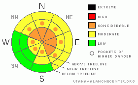
Danger Rose Tutorial
|
At and above treeline the avalanche danger is CONSIDERABLE today for both new and old wind slabs along with deeper, more dangerous avalanches which break into old snow near the ground. Human triggered avalanches are probable on slopes approaching 35 degrees in steepness, especially those facing northwest, north, northeast, east and southeast.
At mid elevations the avalanche danger is generally MODERATE on slopes steeper than 35 degrees facing the north half of the compass and human triggered avalanches are possible. Be aware- you can still trigger deep dangerous avalanches, especially in terrain where the snowpack is less than about 4' deep.
Out of the wind and on most south facing slopes at mid and low elevations the avalanche danger is generally LOW.
|
|
|
CURRENT CONDITIONS |

|
Skies cleared out last night as high pressure starts to strengthen over the region. With a big, bright, beautiful moon overhead, a slight temperature inversion is already taking hold. Currently it’s 10 degrees at 10,000’ and around 7 degrees at the trailhead elevations. Thursday night’s storm was good to the North Slope where nearly a foot of new snow fell. About half that amount fell in terrain south of Weber Canyon. Northwest winds were active yesterday, blowing 15-25 mph along the ridges, gusting to 40 mph along the high peaks. After a brief afternoon respite, they picked back late last night and are currently blowing in the 20’s with gusts in the mid 30’s along the high ridges. Riding and turning conditions vastly improved with this latest shot of new snow and most riders are reporting nearly epic conditions.
|
|
|
RECENT ACTIVITY |

|
A large natural avalanche was spotted on Thursday above Camp Steiner at approx. 11,000 ft. and probably occurred after the Jan. 6th wind event. This avalanche was 8-10 ft. deep, 600-800 ft. wide, running 800 ft. vertical. Thanks Ted for scoping this one out!
For recent accident reports click here
For more photos of recent avalanche activity click here
|
|
|
THREAT #1 |

|
| WHERE |
PROBABILITY |
SIZE |
TREND |
|
|
|
|
| |
|
|
Over the next
24
hours.
|
|
|
The snowpack continues to gain strength and many folks are venturing into steep terrain without any problems, but my gut feeling is I still don’t trust the snowpack. The large natural avalanche near Camp Steiner confirms my suspicions and other dangerous avalanches this week in nearby mountains also have similar characteristics- steep, rocky, wind loaded terrain with a weak underlying snowpack. Sure you can get away with pulling the dog’s tail for a while, but just remember- this one is a vicious Pit Bull and when it bites back, watch out! You can still trigger deep, dangerous and possibly deadly avalanches in steep, rocky terrain especially on slopes facing the north half of the compass which didn’t slide big during the Christmas storm.
Today’s sunny skies, warm temperatures and fresh powder are an intoxicating mixture. Unfortunately this combination can be lethal and the snowpack remains quite complex and deceptive. Please, carefully evaluate each slope and think about the consequences of your terrain decisions.
|
|
|
THREAT #2 |

|
| WHERE |
PROBABILITY |
SIZE |
TREND |
|
|
|
|
| |
|
|
Over the next
24
hours.
|
|
|
A more manageable avalanche situation is the newly formed wind drifts along the leeward side of upper elevation ridges. Today you’ll want to look for and avoid any fat looking pillows of snow. While running within the new storm snow and generally only a foot or so deep, these were quite sensitive yesterday, cracking out well in front of your skis or sled. Once triggered, there’s an isolated possibility that avalanches within the new storm snow could break into weaker snow as they descend the slope, creating a large, unmanageable slide.
|
|
|
MOUNTAIN WEATHER |

|
Mostly sunny skies are on tap for today, though a few clouds and maybe even a flurry or two may drift by as we remain in a northwest flow. Winds are expected to be light at most locations, though along the highest ridges will blow in the 30’s and low 40’s. High temperatures reach into the low 30’s at 8,000’ and mid to upper 20’s at 10,000’. Overnight lows under partly cloudy skies will be near 12 degrees. A quiet weather pattern is on tap for the upcoming week as high pressure builds. We can expect sunny skies and warming temperatures… looks like our January thaw is right on schedule.
|
|
|
GENERAL ANNOUNCEMENTS |
Remember- your observations help to save other riders lives. So if you see or trigger any avalanches please let me know what your seeing. You can reach me at 801-231-2170 or craig@utahavalanchecenter.org
While it's quiet, now is a great time to schedule a free avalanche awareness class for your group or club. You can reach me at 801-231-2170 or craig@utahavalanchecenter.org for more details.
The information in this advisory expires 24 hours after the date and time posted. I'll update this advisory by 7:00 am on Sunday Jan. 11, 2009. |
|
|
This information does not apply to developed ski areas or highways where avalanche control is normally done. This advisory is from the U.S.D.A. Forest Service, which is solely responsible for its content. This advisory describes general avalanche conditions and local variations always occur. |
|
This advisory provided by the USDA Forest Service, in partnership with:
The Friends of the Utah Avalanche Center, Utah Division of State Parks and Recreation, Utah Division of Emergency Management, Salt Lake County, Salt Lake Unified Fire Authority and the friends of the La Sal Avalanche Center. See our Sponsors Page for a complete list. |
