SPECIAL ANNOUNCEMENT |
 |
Thanks to everyone who braved a wicked night of driving and attended last night’s avy clinic hosted by Weller Recreation and Summit County Search and Rescue. What an awesome turnout!
For those of you who missed it and are still looking to brush up on your avy skills, I’ll be giving two more presentations this month- Monday Jan.12th at the S&R building in Heber at 7:00, hosted in part with Plaza Cycle, and Tuesday Jan. 20th at Tri-City Polaris in Centerville at 6:00. Hope to see y’all there. |
|
|
BOTTOM LINE
Danger by aspect and elevation on slopes approaching 35° or steeper.
(click HERE for tomorrow's danger rating)
|
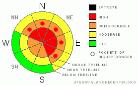
Danger Rose Tutorial
|
At and above treeline the avalanche danger is HIGH today and human triggered avalanches are likely on slopes approaching 35 degrees in steepness, especially those facing northwest, north, northeast, east and southeast. Today’s avalanches will break into weak layers of snow near the ground, creating a large and dangerous slide.
At mid and low elevations the avalanche danger is generally MODERATE, though there are pockets CONSIDERABLE avalanche danger, especially in thin snowpack areas. Dangerous human triggered avalanches are still probable on steep north facing slopes where the pack is less than about 4'.
|
|
|
CURRENT CONDITIONS |

|
High pressure is building in the wake of yesterday’s surprisingly moist system. In the past 24 hours most locations received an evenly disbursed 5” of medium density new snow. Storm totals are close to a foot with an inch of water. The biggers news though is the wind and man is it howling. Westerly winds picked up around 10:00 last night and have been blowing steadily throughout the night and early morning, averaging 25-40 mph with gusts in the 60’s and 70’s along the ridges. Temperatures have been on the rise too and it’s 10 degrees warmer than at this time yesterday morning. Currently at 10,000 it’s in the mid 20’s and at 8,000’ just about 30 degrees. Riding and turning conditions are improving with each storm, but today’s snow will seem kinda funky with an inverted or upside-down feel to it. |
|
|
RECENT ACTIVITY |

|
For recent accident reports click here
For photos of recent avalanche activity click here
|
|
|
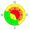
THREAT #1 |

|
| WHERE |
PROBABILITY |
SIZE |
TREND |
|
|
|
|
| |
|
|
Over the next
24
hours.
|
|
|
This may not seem like a large storm and in the big scheme of things it isn’t. However, strong winds, dense snow and rising temperatures all add up to an additional insult on our snowpack which is still on the mend from the Christmas storm. Remember- we have several persistent buried weak layers, both near the ground and surrounding the Thanksgiving rain crust. So we need to think not only what kind of snow we’re riding in, but also what kind of snow we’re riding on. Today’s dense snow will feel supportable and strong… that’s just the problem. It’ll allow a rider to get well out onto a slope before it fails. There is still a very distinct possibility of triggering a deep, dangerous avalanche today which breaks into old snow near the ground, especially in steep, rocky, mid and upper elevation terrain facing the north half of the compass. |
|
|
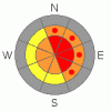
THREAT #2 |

|
| WHERE |
PROBABILITY |
SIZE |
TREND |
|
|
|
|
| |
|
|
Over the next
24
hours.
|
|
|
Fresh wind drifts will be sensitive to the weight of a rider today. Strong winds have formed slabs in unusual places and much lower down slope than you might expect. I’d be suspect of any fat looking, hollow sounding pillow of snow. Once triggered, avalanches within the new fresh wind drifts could easily initiate a deep, wide avalanche creating a much larger slide than you might’ve expected. |
|
|
MOUNTAIN WEATHER |

|
High pressure moves into the state today, but enough moisture remains over northern Utah to keep a few showers in the area this morning. West and northwest winds will be an issue, blowing in the 30’s with gusts in the 40’s and 50’s along the high ridges. By later in the day they should back off into the teens. After the recent deep freeze, temperatures will seem mild with highs at 8,000’ in the mid 30’s and at 10,000’ in the upper 20’s. Overnight lows under clearing skies should bottom out in the upper teens. Sunny skies are on tap for Thursday with another weak system sliding through the region early Friday morning. A ridge of high pressure builds for the weekend into early next week. |
|
|
GENERAL ANNOUNCEMENTS |
Remember- your observations help to save other riders lives. So if you see or trigger any avalanches please let me know what your seeing. You can reach me at 801-231-2170 or craig@utahavalanchecenter.org
While it's quiet, now is a great time to schedule a free avalanche awareness class for your group or club. You can reach me at 801-231-2170 or craig@utahavalanchecenter.org for more details.
The information in this advisory expires 24 hours after the date and time posted. I'll update this advisory by 7:00 am on Saturday Jan. 10, 2009. |
|
|
This information does not apply to developed ski areas or highways where avalanche control is normally done. This advisory is from the U.S.D.A. Forest Service, which is solely responsible for its content. This advisory describes general avalanche conditions and local variations always occur. |
|
This advisory provided by the USDA Forest Service, in partnership with:
The Friends of the Utah Avalanche Center, Utah Division of State Parks and Recreation, Utah Division of Emergency Management, Salt Lake County, Salt Lake Unified Fire Authority and the friends of the La Sal Avalanche Center. See our Sponsors Page for a complete list. |
