SPECIAL ANNOUNCEMENT |
 |
In partnership with Weller Recreation and Summit County Search and Rescue, I’ll be giving a free avalanche awareness presentation on Tuesday Jan. 6th at 7:00 in Kamas at the Search and Rescue building on 45 East 100 North. |
|
|
BOTTOM LINE
Danger by aspect and elevation on slopes approaching 35° or steeper.
(click HERE for tomorrow's danger rating)
|
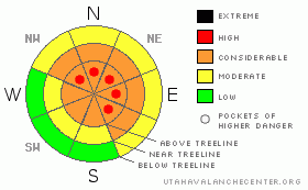
Danger Rose Tutorial
|
At and above treeline the avalanche danger is CONSIDERABLE with pockets of HIGH danger, but the consequences of triggering an avalanche are severe on all slopes approaching 35 degrees in steepness, especially those facing northwest, north, northeast, east and southeast. Human triggered avalanches are probable. Today’s avalanches will break into weak layers of snow near the ground, creating a large, dangerous and possibly unsurvivable slide.
At mid elevations the avalanche danger is generally MODERATE, though there are pockets CONSIDERABLE avalanche danger, especially in thin snowpack areas and human triggered avalanches are probable where the pack is less than about 4'.
Remember- even if you're traveling on relatively flat terrain, be aware of steep slopes above and adjacent to you. |
|
|
CURRENT CONDITIONS |

|
Hope you plugged in your block heater, cause man it’s cold outside this morning. Under clear skies overnight temperatures crashed faster then a Lehman Brothers stock option. Currently it’s -14 degrees at Trial Lake, -11 degrees at most trailheads and not to be out done, Lily Lake checks in with a Siberian-like -25 degrees. Winds are light and variable even along the high peaks, blowing less than 15 mph. If you can brave the brutal temperatures, you’ll be rewarded with deep cold smoke. |
|
|
RECENT ACTIVITY |

|
For recent accident reports click here
For photos of recent avalanche activity click here
|
|
|
THREAT #1 |

|
| WHERE |
PROBABILITY |
SIZE |
TREND |

|
|
|
|
| |
|
|
Over the next
24
hours.
|
|
|
The snowpack has gained a little strength since the mid week warm up and that’s the good news. The bad news is Ted and I are still finding weak snow near the ground, both above and below the Thanksgiving rain crust, that’s reactive in our snowpit tests, especially in terrain where the snowpack is less than about 4’ deep. (Click here to see this weak snow in action... thanks Derek!).
Where the pack is deeper, we’re starting to “bridge” over some of the weaknesses and things aren’t quite as tender. Remember though, we tend to trigger deep, dangerous slides from thin spots in the snowpack not where it’s thick and strong. I’d continue avoiding mid slope break overs and steep terrain with bushes and rocks poking out of it. (Click here for more pit profiles)
If you want to get into steep terrain without incident, look for slopes that have avalanched near the ground recently. Other steep slopes that remained intact throughout the Christmas storm still hang in the balance waiting for a trigger. While the big, deep, dangerous avalanches are getting tougher to trigger, if you do tip the balance the consequences are devastating. |
|
|
THREAT #2 |

|
| WHERE |
PROBABILITY |
SIZE |
TREND |

|
|
|
|
| |
|
|
Over the next
24
hours.
|
|
|
There may be an old wind slab or two lingering along the ridges and other leeward terrain features, but in general these are isolated to the upper elevations. A heads up is in order here though- once triggered these slabs could initiate a deeper avalanche as they descend the slope, creating a bigger slide than you bargained for. |
|
|
MOUNTAIN WEATHER |

|
Cold, high pressure will remain in place through the day with a slight warming trend on tap starting Monday. Highs at 8,000’ barely reach into the low teens; at 10,000’ we might see 5 degrees. Overnight lows will be near zero. Winds remain light, less than 15 mph today, but should increase slightly tonight and Monday as a storm system works its way into the region. A decent shot of snow for Monday night into Tuesday, brief high pressure builds for Wednesday and another weak system is slated for Thursday.
|
|
|
GENERAL ANNOUNCEMENTS |
Remember- your observations help to save other riders lives. So if you see or trigger any avalanches please let me know what your seeing. You can reach me at 801-231-2170 or craig@utahavalanchecenter.org
While it's quiet, now is a great time to schedule a free avalanche awareness class for your group or club. You can reach me at 801-231-2170 or craig@utahavalanchecenter.org for more details.
The information in this advisory expires 24 hours after the date and time posted. I'll update this advisory by 7:00 am on Wednesday Jan. 7, 2009. |
|
|
This information does not apply to developed ski areas or highways where avalanche control is normally done. This advisory is from the U.S.D.A. Forest Service, which is solely responsible for its content. This advisory describes general avalanche conditions and local variations always occur. |
|
This advisory provided by the USDA Forest Service, in partnership with:
The Friends of the Utah Avalanche Center, Utah Division of State Parks and Recreation, Utah Division of Emergency Management, Salt Lake County, Salt Lake Unified Fire Authority and the friends of the La Sal Avalanche Center. See our Sponsors Page for a complete list. |
