BOTTOM LINE
Danger by aspect and elevation on slopes approaching 35° or steeper.
(click HERE for tomorrow's danger rating)
|
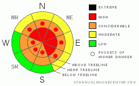
Danger Rose Tutorial
|
At and above treeline the avalanche danger remains HIGH today with severe consequences on all slopes approaching 30 degrees in steepness, especially those with recent deposits of wind drifted snow facing northwest, north, northeast and east. Human triggered avalanches are likely. Today’s avalanches will break into weak layers of snow near the ground, creating a large, dangerous and possibly unsurvivable slide.
At mid elevations the avalanche danger is CONSIDERABLE on steep wind drifted slopes and human triggered avalanches are probable.
Remember- even if you're traveling on relatively flat terrain, be aware of steep slopes above and adjacent to you and avoid avalanche runout zones. |
|
|
CURRENT CONDITIONS |

|
Happy New Year! Under partly cloudy skies, temperatures are in the upper teens at 10,000’ and mid 20’s at the trailheads. Yesterday’s gusty ridge top winds reached a crescendo last night, blowing into the 60’s along the high peaks, but have mellowed out this morning and are now westerly, averaging 15-25 mph with gusts in the low 40’s along the ridges. Riding and turning conditions are quite good in low angled, wind sheltered terrain. |
|
|
RECENT ACTIVITY |

|
We took a look at the Yamaha Hill avalanche accident which resulted in the death of a 15 year old Evanston resident. This incident saddens me deeply and my thoughts and prayers go out to the friends and family of Hayden Ellingford. I will have a detailed accident report available once details get sifted through.
Our preliminary investigation revealed the avalanche was triggered low on the slope in a thin, weak area of the snowpack in terrain that you would consider relatively benign. Unfortunately, the slide kicked the legs out from under a very cohesive slab leading to a larger than usual avalanche for this slope. Occurring on a northeast aspect at about 10,200’ in elevation, this slide averaged 4’ (10’ at its deepest point) was approx. 600’ wide and ran for about 500 vertical feet. Classified as a HS-AM-D2-R3-O/G. The starting zone averages 32 degrees in steepness with several small mid slope break-overs measuring 36 degrees. The avalanche failed on a thin layer of faceted snow above the Thanksgiving raincrust. Thanks to Rick Schuler and Ted Scroggin for all your help. Also thanks to Kendall Card and Alex Pashley for the great photos and observations.
For more photos of recent avalanche activity and snowpit profiles click here |
|
|
THREAT #1 |

|
| WHERE |
PROBABILITY |
SIZE |
TREND |
|
|
|
|
| |
|
|
Over the next
24
hours.
|
|
|
Not much has changed since yesterday's advisory... including my wording. The snowpack remains at a dangerous crossroads and as usual, it’s reluctant to reveal its secrets. The pack is gaining strength and we’re done with the eye popping natural avalanche cycle. As a matter fact people are starting to get into terrain that would’ve led to certain disaster just a few days ago. Unfortunately our snowpack remains quite complex and snow stability tests can be misleading. As we pieced Monday’s incident together, tweaking the snow along the flanks and crown of the slide, it became apparent just how tricky the snowpack is right now and there’s a couple factors to consider.
First- hard slab avalanches, like the kind of avalanche dragon we’re dealing with right now, are triggered from weak spots in the snowpack, not where it’s thick and strong. Rocks, bushes and small trees poking up through the snow are likely trigger points and the kind of terrain features we need to avoid, especially when they’re connected to a steep slopes above and adjacent to us.
Secondly- the Thanksgiving rain crust is an unusual variable in our snowpack and it’s everywhere. What makes this condition particularly problematic is the crust is strong enough to support a remarkably large amount of snow, but a weak layer of faceted snow is lurking just above this deceptive demon, giving us all the ingredients for a dangerous slab avalanche. In addition, the crust is expanding the normal boundaries of slide paths, making them much wider than usual and connecting adjacent slopes to the ones your riding. Another fly in the ointment is avalanches are running in treed terrain and areas we normally think of as safe.
Finally- just like Vegas, it’s a roll of the dice out there right now and the overall snow stability pattern is murky at best. You may be able to nose into some steep terrain without incident, essentially stacking your chips and cheating the house for awhile. However one thing is clear- if you trigger an avalanche it’ll be large and dangerous and the consequences are devastating. Remember- the house always wins. If we want to increase our odds, we’ll just need to chill out, tone our slope angles down and have some patience as the snowpack adjusts. Right now, meadows and groomed trails are the ticket. Even if you’re playing in flat terrain think about steep slopes above and adjacent to you and avoid avalanche runout zones. |
|
|
THREAT #2 |

|
| WHERE |
PROBABILITY |
SIZE |
TREND |
|
|
|
|
| |
|
|
Over the next
24
hours.
|
|
|
Recent westerly winds created a whole new round of wind slabs sensitive to the weight of a rider. Once triggered, these fairly manageably sized slabs can quickly get out of hand initiating a much larger, wider and more dangerous avalanche than you bargained for.
|
|
|
MOUNTAIN WEATHER |

|
A weak weather system moves in from the north today and we should see increasing clouds and a light snow shower or two. Accumulations will be about an inch or so. Westerly winds increase throughout the day, generally blowing 15-25 mph gusting into the 40’s along the ridges. Highs today at 8,000’ will be in the mid 30’s, at 10,000’ near freezing. Overnight lows dip into the mid 20’s. Winds switch to the southwest on Friday, gusting into the 50’s, ushering in a decent cold front which impacts the region late Friday night into Saturday. This doesn’t look like a big storm, rather a quick hitter with about 6” of new snow expected. |
|
|
GENERAL ANNOUNCEMENTS |
Remember- your observations help to save other riders lives. So if you see or trigger any avalanches please let me know what your seeing. You can reach me at 801-231-2170 or craig@utahavalanchecenter.org
While it's quiet, now is a great time to schedule a free avalanche awareness class for your group or club. You can reach me at 801-231-2170 or craig@utahavalanchecenter.org for more details.
The information in this advisory expires 24 hours after the date and time posted. I'll update this advisory by 7:00 am on Saturday Jan. 3, 2009. |
|
|
This information does not apply to developed ski areas or highways where avalanche control is normally done. This advisory is from the U.S.D.A. Forest Service, which is solely responsible for its content. This advisory describes general avalanche conditions and local variations always occur. |
|
This advisory provided by the USDA Forest Service, in partnership with:
The Friends of the Utah Avalanche Center, Utah Division of State Parks and Recreation, Utah Division of Emergency Management, Salt Lake County, Salt Lake Unified Fire Authority and the friends of the La Sal Avalanche Center. See our Sponsors Page for a complete list. |
