SPECIAL ANNOUNCEMENT |
 |
An AVALANCHE WARNING remains in effect for the western Uinta Mountains. Strong winds and recent heavy snow overloaded an extremely weak snowpack. A HIGH avalanche danger exists on all steep mid and upper elevation slopes. Human triggered avalanches are certain, natural avalanches are likely. Backcountry travel is not recommended. |
|
|
BOTTOM LINE
Danger by aspect and elevation on slopes approaching 35° or steeper.
(click HERE for tomorrow's danger rating)
|
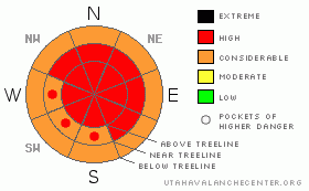
Danger Rose Tutorial
|
At and above treeline the avalanche danger remains HIGH today with extreme consequences on all slopes approaching 30 degrees in steepness, especially those with recent deposits of wind drifted snow. Human triggered avalanches are likely. Today’s avalanches will break into weak layers of snow near the ground, creating a large, dangerous and possibly unsurvivable slide.
At mid elevations the avalanche danger is CONSIDERABLE on steep wind drifted slopes and human triggered avalanches are probable.
Remember- even if you're traveling on relatively flat terrain, be aware of steep slopes above and adjacent to you and avoid avalanche runout zones. |
|
|
CURRENT CONDITIONS |

|
Partly cloudy skies developed overnight and man is it cold out there this morning. Currently it’s -5 degrees at 10,000’ and a more tolerable 4 degrees at 8,000’. West and northwest winds are blowing 10-20 mph at most locations, gusting into the 30’s along the high ridges, putting wind chill values along the exposed peaks at around -37 degrees. The Christmas storm was good to the range and most upper elevation terrain received 18” of snow, with some areas favored by a southwest flow getting close to 2’.
|
|
|
RECENT ACTIVITY |

|
Tuesday’s unfortunate avalanche accident in the Logan Mountains resulted in the death of two local snowmobilers. My thoughts and prayers go out to friends and family of these two young men. You can check out the accident report by clicking on the Logan advisory.
Closer to home, the region is experiencing an active avalanche cycle which started Sunday. Very large natural avalanches along with snowcat, remotely triggered, intentionally human triggered and explosives triggered (photo one, photo two) avalanches have been reported. Averaging 3’-4’ deep, all the slides are breaking on or just below the Thanksgiving rain crust near the ground and are up to 400’ wide. In addition, avalanches are breaking out along ridgelines in relatively flat terrain. Also, Joe Donnell from the State Parks grooming crew triggered numerous slides yesterday on the Wolf Creek/Soapstone Road. Any one of these benign looking slopes could easily bury a person.
Thanks everyone for all the awesome observations this week! I especially want to thank Ted Scroggin, Joe Donnell and the staff at Park City Powder Cats for their professional dialog, advice and insight during this challenging avalanche cycle. Check out more photos here. |
|
|
THREAT #1 |

|
| WHERE |
PROBABILITY |
SIZE |
TREND |
|
|
|
|
| |
|
|
Over the next
24
hours.
|
|
|
Impressive snow and water totals from the Christmas storm left our weak snowpack reeling. Persistent buried weaknesses in our snowpack need time to adjust and we’ll need to have patience as the pack begins to heal. The goods news is the region experienced a widespread natural avalanche cycle and some of our worries have been flushed away. The bad news is most of the evidence is covered over with new snow making it hard to detect exactly which slopes have avalanched. Many steep slopes hang in the balance waiting for a trigger to come along and knock the legs out from under our structurally challenged snowpack.
Not much has changed the past few days and it remains spooky and unpredictable out there. You know it’s dangerous when you’re seeing natural avalanches in unusual places or even along the highway on your way to where you’re riding. Avalanches triggered today will be large, dangerous and most certainly unsurvivable. They can be triggered from a distance and on relatively flat terrain. In addition, avalanches are being triggered from ridgelines and over running islands of safety. Avalanche conditions will remain tricky for several more days as the snowpack tries to adjust, so you’ll need to tone your ambitions down a few notches and stick with low angle slopes and groomed trails. Remember- even if you’re playing in flat terrain think about steep slopes above and adjacent to you and avoid avalanche runout zones. |
|
|
THREAT #2 |

|
| WHERE |
PROBABILITY |
SIZE |
TREND |
|
|
|
|
| |
|
|
Over the next
24
hours.
|
|
|
Winds have been active all week, creating fresh drifts along the leeward side of ridges and around terrain features like chutes and gullies at the mid and upper elevations. Wind slabs remain sensitive to the weight of a rider. Once triggered, these manageably sized slabs can quickly get out of hand initiating a much larger, wider and more dangerous avalanche than you bargained for.
|
|
|
MOUNTAIN WEATHER |

|
A moist northwest flow will keep light snow showers going throughout the weekend, though no big accumulations are expected. It’ll remain cold today with highs only getting into the low teens at 8,000’ and near 7 degrees at 10,000’. Overnight lows will be around 5 degrees. West and northwest winds remain brisk along the ridges, blowing in the 30’s and low 40’s. Partly cloudy skies are on tap for Sunday. A slight warming trend develops during the next few days with the possibility of a small storm grazing the region Monday night.
|
|
|
GENERAL ANNOUNCEMENTS |
Remember- your observations help to save other riders lives. So if you see or trigger any avalanches please let me know what your seeing. You can reach me at 801-231-2170 or craig@utahavalanchecenter.org
While it's quiet, now is a great time to schedule a free avalanche awareness class for your group or club. You can reach me at 801-231-2170 or craig@utahavalanchecenter.org for more details.
The information in this advisory expires 24 hours after the date and time posted. I'll update this advisory by 7:00 am on Sunday Dec. 28, 2008. |
|
|
This information does not apply to developed ski areas or highways where avalanche control is normally done. This advisory is from the U.S.D.A. Forest Service, which is solely responsible for its content. This advisory describes general avalanche conditions and local variations always occur. |
|
This advisory provided by the USDA Forest Service, in partnership with:
The Friends of the Utah Avalanche Center, Utah Division of State Parks and Recreation, Utah Division of Emergency Management, Salt Lake County, Salt Lake Unified Fire Authority and the friends of the La Sal Avalanche Center. See our Sponsors Page for a complete list. |
