SPECIAL ANNOUNCEMENT |
 |
An AVALANCHE WARNING remains in effect for the western Uinta Mountains. Strong winds and recent heavy snow overloaded an extremely weak snowpack. A HIGH avalanche danger exists on all steep mid and upper elevation slopes. Human triggered avalanches are certain, natural avalanches are likely. Backcountry travel is not recommended. |
|
|
BOTTOM LINE
Danger by aspect and elevation on slopes approaching 35° or steeper.
(click HERE for tomorrow's danger rating)
|
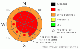
Danger Rose Tutorial
|
At and above treeline the avalanche danger remains HIGH today with extreme consequences on all slopes approaching 30 degrees in steepness, especially those with recent deposits of wind drifted snow. Human triggered avalanches are likely. Today’s avalanches will break into weak layers of snow near the ground, creating a large, dangerous and possibly unsurvivable slide.
At mid elevations the avalanche danger is CONSIDERABLE on steep wind drifted slopes and human triggered avalanches are probable.
Remember- even if you're traveling on relatively flat terrain, be aware of steep slopes above and adjacent to you and avoid avalanche runout zones. |
|
|
CURRENT CONDITIONS |

|
Wow… what a storm! After a day of raging southwest winds and snow, the much anticipated cold front finally got here around 8:00 last night. Winds switched to the west and northwest, quickly dying down into a more reasonable 15-20 mph, though along the high ridges it’s still blowing 30-40 mph. Storm totals are impressive and everyone’s gotten in on the act. There’s a conservative 18” at Trial Lake, 16” at Chalk Creek, 13” at Daniels and a foot at the trailheads…. it stomped! Temperatures rapidly fell overnight and currently it’s 8 degrees at 10,000’ and 12 degrees at the trailheads.
|
|
|
RECENT ACTIVITY |

|
Tuesday’s unfortunate avalanche accident in the Logan Mountains resulted in the death of two local snowmobilers. My thoughts and prayers go out to friends and family of these two young men. You can check out the accident report by clicking on the Logan advisory.
Closer to home, the region is experiencing an active avalanche cycle which started Sunday. Very large natural avalanches along with snowcat, remotely triggered, intentionally human triggered and explosives triggered (photo one, photo two) avalanches have been reported. Averaging 3’-4’ deep, all the slides are breaking on or just below the Thanksgiving rain crust near the ground and are up to 400’ wide. In addition, avalanches are breaking out along ridgelines in relatively flat terrain.
Thanks everyone for all the awesome observations this week! I especially want to thank Ted Scroggin and the staff at Park City Powder Cats for their professional dialog, advice and insight during this challenging avalanche cycle. Check out more photos here. |
|
|
THREAT #1 |

|
| WHERE |
PROBABILITY |
SIZE |
TREND |

|
|
|
|
| |
|
|
Over the next
24
hours.
|
|
|
We got walloped and our weak snowpack is cringing right now just thinking about the impressive snow and water totals. With 18” of snow and nearly 1.5” of water, coupled with nuking winds, I expect the region experienced a fairly widespread natural avalanche cycle yesterday. Unfortunately much of the evidence will be hard to detect today, as many crowns rapidly filled back in with additional new snow last night.
If you pull the dogs tail enough times, you’re gonna get bit and the conditions we’re experiencing right now are nothing to mess with. There’s no reason to talk about whether things will fail above or below the rain crust or which weak layer is responsible. It’s spooky and unpredictable out there. Avalanches triggered today will be large, dangerous and most certainly unsurvivable. They can be triggered from a distance and on relatively flat terrain. In addition, avalanches are being triggered from ridgelines and over running islands of safety. Avalanche conditions will remain tricky for several more days as the snowpack tries to adjust, so you’ll need to tone your ambitions down a few notches and stick with low angle slopes and groomed trails. Remember- even if you’re playing in flat terrain think about steep slopes above and adjacent to you and avoid avalanche runout zones.
|
|
|
THREAT #2 |

|
| WHERE |
PROBABILITY |
SIZE |
TREND |
|
|
|
|
| |
|
|
Over the next
24
hours.
|
|
|
Winds have been active for several days, creating fresh drifts along the leeward side of ridges at the mid and upper elevations and these are sensitive to the weight of a rider. Once triggered, these manageably sized slabs can quickly get out of hand initiating a much larger, wider and more dangerous avalanche than you bargained for.
|
|
|
MOUNTAIN WEATHER |

|
The storm that slammed the state yesterday is east of us, though cold unstable air should keep snow showers going for most of the day with additional accumulations near 4”. Northwest winds diminish throughout the day backing off into the low 20’s with gusts in the 30’s along the high, exposed ridges. Temperatures should be dropping this morning and it’ll be cold today with highs only reaching into the upper single digits at 8,000’ and near zero at 10,000’. Overnight lows will be around -5 degrees. Isolated snow showers and cold temperatures continue through Sunday.
|
|
|
GENERAL ANNOUNCEMENTS |
Remember- your observations help to save other riders lives. So if you see or trigger any avalanches please let me know what your seeing. You can reach me at 801-231-2170 or craig@utahavalanchecenter.org
While it's quiet, now is a great time to schedule a free avalanche awareness class for your group or club. You can reach me at 801-231-2170 or craig@utahavalanchecenter.org for more details.
The information in this advisory expires 24 hours after the date and time posted. I'll update this advisory by 7:00 am on Saturday Dec. 27, 2008. |
|
|
This information does not apply to developed ski areas or highways where avalanche control is normally done. This advisory is from the U.S.D.A. Forest Service, which is solely responsible for its content. This advisory describes general avalanche conditions and local variations always occur. |
|
This advisory provided by the USDA Forest Service, in partnership with:
The Friends of the Utah Avalanche Center, Utah Division of State Parks and Recreation, Utah Division of Emergency Management, Salt Lake County, Salt Lake Unified Fire Authority and the friends of the La Sal Avalanche Center. See our Sponsors Page for a complete list. |
