SPECIAL ANNOUNCEMENT |
 |
An AVALANCHE WARNING is in effect for the western Uinta Mountains. Strong winds and expected heavy snow will overload an extremely weak snowpack. A HIGH avalanche danger exists on all steep mid and upper elevation slopes. Both human triggered and natural avalanches are likely. Backcountry travel is not recommended. |
|
|
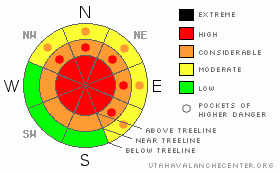
BOTTOM LINE
Danger by aspect and elevation on slopes approaching 35° or steeper.
(click HERE for tomorrow's danger rating)
|
Danger Rose Tutorial
|
At and above treeline the avalanche danger remains HIGH today on all slopes approaching 35 degrees in steepness, especially those with recent deposits of wind drifted snow. Human triggered avalanches are likely. Today’s avalanches have the possibility of breaking into weak layers of snow near the ground, creating a large, dangerous and possibly unsurvivable slide.
At mid elevations the avalanche danger is CONSIDERABLE on steep wind drifted slopes and human triggered avalanches are probable.
A LOW avalanche danger exists on low angle wind protected slopes, especially those at lower elevations that were void of snow prior to the recent series of storms. Remember- even if you're traveling on relatively flat terrain, be aware of steep slopes above and adjacent to you and avoid avalanche runout zones. |
|
|
CURRENT CONDITIONS |

|
A break in the action is on tap before the next powerful Pacific storm slams into the region. Speaking of storms, Monday’s system clobbered the western Uinta’s with 16” of new snow and very strong winds. Westerly winds remained active yesterday, gusting into the 40’s and 50’s along the high peaks. Winds relaxed overnight, switched to the southwest early this morning and are currently blowing 10-20 mph. Skies cleared out for a short time last night, allowing temperatures to dive into negative territory. Trailhead temperatures are near zero and it’s just about -5 degrees at 10,000’.
|
|
|
RECENT ACTIVITY |

|
The region went through an active avalanche cycle Sunday and Monday. Very large natural avalanches along with snowcat, remotely triggered and intentionally human triggered avalanches have been reported. Averaging 3’-4’ deep, all the slides are breaking on or just below the Thanksgiving rain crust near the ground and are up to 300’ wide. Thanks everyone for all the awesome observations this week! I especially want to thank Ted Scroggin and the staff at Park City Powder Cats for their professional dialog, advice and insight. Check out more photos here. |
|
|
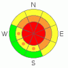
THREAT #1 |

|
| WHERE |
PROBABILITY |
SIZE |
TREND |
|
|
|
|
| |
|
|
Over the next
24
hours.
|
|
|
I’ve been working in the snow and avalanche business nearly half my life and I’ve never seen a more dangerous setup than we have right now. Yesterday I jumped off my sled to dig into a safe test slope about 20 degrees in steepness. As I approached the slope, it catastrophically collapsed with a booming, shotgun-like whoomph, shaking small trees and knocking snow out of them. Shooting cracks were everywhere and the slope dropped several inches. Man, if that isn’t enough to catch your attention. My heart was racing like I just downed a six-pack of Red Bulls!
It’s a peculiar snowpack for us and here’s what’s going on. Very weak faceted snow near the ground is something we’re used to dealing with in the western Uinta Mountains… heck it’s what we’re famous for. However this year the snowpack is far more complex. Not only do we have our usual rotten facets to contend with, nature threw in a wild card this year just to keep us on our toes. Rain crusts, like the one formed on Thanksgiving, are unusual for our neck of the woods and it’s something we’re not used to seeing. Remember- unusual weather makes for unusual avalanches. The rain crust acts like a supportable layer, giving the snowpack some strength, allowing a slab to develop on top of the weak junk show below. The snowpack feels like it has some body and structure and that’s just the problem. The deceptive curve ball is there’s no strength underneath.
I know we’ve been powder starved this year and the riding is just starting to get good, but for the next few days you’ll need to think about the consequences of your terrain choices. It’s extremely deceptive out there and avalanches triggered today are certain to be large, dangerous and unsurvivable. |
|
|
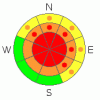
THREAT #2 |

|
| WHERE |
PROBABILITY |
SIZE |
TREND |
|
|
|
|
| |
|
|
Over the next
24
hours.
|
|
|
Winds have been active for several days, creating fresh drifts along the leeward side of ridges at the mid and upper elevations and these are sensitive to the weight of a rider. Once triggered, these manageably sized slabs can quickly get out of hand initiating a much larger, wider and more dangerous avalanche than you bargained for.
|
|
|
MOUNTAIN WEATHER |

|
A major winter storm begins to affect the region later today, lingering through early Friday. A moist, southwest flow should have snow developing around dinner time.
Southwest winds increase throughout the day, blowing in the 30’s and 40’s with gusts in the 60’s by late tonight. Today’s high temperatures reach into the low 20’s at 8,000’ and in the mid teens at 10,000’. Overnight lows will be near 20 degrees. The cold front roars into the region late Christmas Day and snowfall rates could be pretty intense. We should fair well with this storm and it looks like an 18” storm total isn’t out of the question.
|
|
|
GENERAL ANNOUNCEMENTS |
Remember- your observations help to save other riders lives. So if you see or trigger any avalanches please let me know what your seeing. You can reach me at 801-231-2170 or craig@utahavalanchecenter.org
While it's quiet, now is a great time to schedule a free avalanche awareness class for your group or club. You can reach me at 801-231-2170 or craig@utahavalanchecenter.org for more details.
The information in this advisory expires 24 hours after the date and time posted. I'll update this advisory by 7:00 am on Thursday Dec. 25, 2008. |
|
|
This information does not apply to developed ski areas or highways where avalanche control is normally done. This advisory is from the U.S.D.A. Forest Service, which is solely responsible for its content. This advisory describes general avalanche conditions and local variations always occur. |
|
This advisory provided by the USDA Forest Service, in partnership with:
The Friends of the Utah Avalanche Center, Utah Division of State Parks and Recreation, Utah Division of Emergency Management, Salt Lake County, Salt Lake Unified Fire Authority and the friends of the La Sal Avalanche Center. See our Sponsors Page for a complete list. |
