SPECIAL ANNOUNCEMENT |
 |
AN AVALANCHE WARNING IS IN EFFECT FOR THE WESTERN UINTA MOUNTAINS. STRONG WIND AND RECENT SNOW OVERLOADED BURIED WEAK LAYERS WITHIN THE SNOWPACK, CREATING A HIGH DANGER OF HUMAN TRIGGERED AND NATURAL SLAB AVALANCHES. DANGEROUS BACKCOUNTRY CONDITIONS WILL PERSIST THROUGH THE WEEKEND. |
|
|
BOTTOM LINE
Danger by aspect and elevation on slopes approaching 35° or steeper.
(click HERE for tomorrow's danger rating)
|
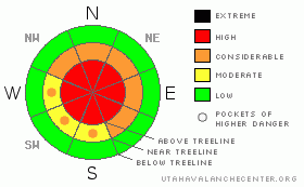
Danger Rose Tutorial
|
At and above treeline the avalanche danger is HIGH today on all slopes approaching 35 degrees in steepness, especially those facing the north half of the compass with recent deposits of wind drifted snow. Both human triggered and natural avalanches are likely. Today’s avalanches have the possibility of breaking into weak layers of snow near the ground, creating a large, dangerous and possibly unsurvivable slide.
At mid elevations the avalanche danger is CONSIDERABLE on steep wind drifted slopes and human triggered avalanches are probable.
A LOW avalanche danger exists on low angle wind protected slopes, especially those at lower elevations that were void of snow prior to the recent series of storms. |
|
|
CURRENT CONDITIONS |

|
Yesterday’s cold front roared into the region and storm totals are pretty evenly distributed throughout the range. It looks like we picked up 7” of light density cold smoke above about 9,500’ and down at the trailheads totals are half that amount, in the 3”-4” range. The big news is the hurricane force winds. Yesterday’s prefrontal winds blew out of the southwest, averaging 40 mph with gusts in the 70’s along the high ridges. After an early evening lull, they switched to the west and northwest and are currently blowing 20-40 mph with gusts in the 60’s along the peaks. It’s cold out there this morning with trailhead temperatures near 7 degrees and at 10,000’ it’s -1. Wind chills are nearing -40 degrees in exposed, upper elevation terrain. Riding and turning conditions improve each day and now our upper elevation snowpack averages a fairly respectable 3’ in depth.
|
|
|
RECENT ACTIVITY |

|
Visibility has been limited lately, so no new avalanche activity to report on the eastern front. However, it’s coming unglued in neighboring terrain, especially on the Park City ridgeline which is a good stability barometer for us. |
|
|
THREAT #1 |

|
| WHERE |
PROBABILITY |
SIZE |
TREND |
|
|
|
|
| |
|
|
Over the next
24
hours.
|
|
|
It’s the real deal out there today and avalanche conditions are downright dangerous- here’s what’s going on. This season we’ve been in a tenuous balance between the strength of the snowpack and the stress applied to it and so far our structurally challenged pack has been able to adjust. But that all changed in a big way with the arrival of yesterday’s storm. Raging winds formed a strong, cohesive slab above the dangerously persistent weak, sugary, early season faceted snow near the ground. Unfortunately, the strong feeling slab can easily give you a false sense of snowpack stability, luring a rider onto steep slopes before they catastrophically fail on these buried weak layers. In addition, it’s deceptively tricky right now and you don’t have to be on a radically steep slope to trigger avalanches. In fact, you can trigger them from a distance and on relatively flat terrain. Even if you’re on low angle slopes today you’ll need to avoid avalanche runout zones and think about steep slopes above and adjacent to where you’re riding.
Remember- many avalanche accidents occur early in the season when we don’t think there’s enough snow to slide. So if you’re starting off in low elevation terrain, riding through fields of sage brush barely covered over with new snow, remember up high it’s winter and it’s dangerous. Avalanches triggered today will be deep, wide and most likely unsurvivable. |
|
|
THREAT #2 |

|
| WHERE |
PROBABILITY |
SIZE |
TREND |
|
|
|
|
| |
|
|
Over the next
24
hours.
|
|
|
Gusty winds yesterday and again overnight formed slabs on just about every aspect and elevation out there and I think you’ll find wind drifts in unusual locations. Due to the strength of the wind, drifts formed much lower downslope than you might expect. Breakovers, chutes, gullies and sub-ridges should all be approached with caution. Avalanches triggered within the newly drifted snow can easily break into deeper buried weak layers, creating a much bigger and more dangerous slide than you might’ve bargained for. |
|
|
MOUNTAIN WEATHER |

|
Yesterday’s powerful storm will be pounding the Midwest later today and in its wake we’re left with a cold, northwest flow. Today we can expect scattered snow showers, strong ridgetop winds and very cold temperatures. Winds will blow out of the west and northwest with hourly averages in the 20’s and 30’s, gusting into the 50’s along the high ridges. Temperatures will be hard pressed to climb above 10 degrees at 8,000’ and should remain in the low single digits at 10,000’. Overnight lows will be near -10 degrees. A weak ridge builds later tonight into Sunday giving us partly cloudy skies and warming temperatures, before a warmer storm on a southwest flow affects the region early in the week.
|
|
|
GENERAL ANNOUNCEMENTS |
Remember- your observations help to save other riders lives. So if you see or trigger any avalanches please let me know what your seeing. You can reach me at 801-231-2170 or craig@utahavalanchecenter.org
While it's quiet, now is a great time to schedule a free avalanche awareness class for your group or club. You can reach me at 801-231-2170 or craig@utahavalanchecenter.org for more details.
The information in this advisory expires 24 hours after the date and time posted. I'll update this advisory by 7:00 am on Sunday Dec. 21, 2008. |
|
|
This information does not apply to developed ski areas or highways where avalanche control is normally done. This advisory is from the U.S.D.A. Forest Service, which is solely responsible for its content. This advisory describes general avalanche conditions and local variations always occur. |
|
This advisory provided by the USDA Forest Service, in partnership with:
The Friends of the Utah Avalanche Center, Utah Division of State Parks and Recreation, Utah Division of Emergency Management, Salt Lake County, Salt Lake Unified Fire Authority and the friends of the La Sal Avalanche Center. See our Sponsors Page for a complete list. |
