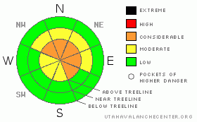
BOTTOM LINE
Danger by aspect and elevation on slopes approaching 35° or steeper.
(click HERE for tomorrow's danger rating)
|
Danger Rose Tutorial
|
Above treeline the avalanche danger is CONSIDERABLE on slopes steeper than about 35 degrees, especially those facing the north half of the compass with recent deposits of wind drifted snow. Human triggered avalanches are probable. In addition, there’s a CONSIDERABLE danger of triggering avalanches today that have the possibility of breaking into weak layers of snow near the ground, creating a larger and more dangerous avalanche than you might expect.
At mid elevations the avalanche danger is MODERATE on steep wind drifted slopes and human triggered avalanches are possible.
While a LOW avalanche danger exists on slopes void of snow prior to yesterday’s storm, be aware of steep slopes above and adjacent to you. |
|
|
CURRENT CONDITIONS |

|
The weekend storm is winding down and most areas faired pretty well with an evenly distributed 10” of new light density snow stacking up at the upper elevations. The trailheads elevations didn’t do too badly either with up to 6” at most locations. Yesterday’s gusty west and northwest winds relaxed overnight at the mid elevations and are blowing 10-20 mph. Along the high ridges though winds have been blowing steadily in the 30’s, gusting in the mid 40’s. Temperatures rapidly crashed overnight and currently it’s just about zero at 10,000’ and 8 degrees at 8,000’. Riding and turning conditions improved drastically with the storm, but it’s still a little thin out there with an average snow depth hovering right around two feet.
|
|
|
RECENT ACTIVITY |

|
One human triggered pocket reported on a steep, mid elevation wind loaded slope. |
|
|
THREAT #1 |

|
| WHERE |
PROBABILITY |
SIZE |
TREND |
|
|
|
|
| |
|
|
Over the next
24
hours.
|
|
|
The combination of new snow and strong gusty winds yesterday created widespread wind drifts at the mid and upper elevations and riders reported very sensitive slabs forming in unusual locations, lower downslope than you might expect. I think for the most part many of these fresh slabs probably relaxed overnight and won’t be quite as reactive to the weight of a rider today, though now they’ve been covered over with new snow and will be harder to detect. Today you’ll want to look for obvious snow instability clues like shooting cracks and continue to avoid any fat looking rounded pillow of snow which is most prevalent on the leeward side of ridges, chutes and gullies. While manageable in size, be aware today’s wind slabs have the possibility of breaking into weaker snow near the ground especially on slopes facing the north half of the compass that had preexisting snow prior to the weekend storm. |
|
|
THREAT #2 |

|
| WHERE |
PROBABILITY |
SIZE |
TREND |
|
|
|
|
| |
|
|
Over the next
24
hours.
|
|
|
The deeper instabilities in the snowpack got cranky yesterday and on steep slopes with a thin, shallow snowpack it was easy to trigger pockety avalanches which failed on weak snow near the ground. Ted and his partner Justin triggered a nice little pocket on a small test slope as they barely sliced the ski of their sled into the slab. The rain crust/facet sandwich I’ve been talking about for the past few weeks was the culprit and this instability hasn’t healed overnight. If anything our structurally challenged snowpack is maxed out right now and will need sometime to adjust to yesterdays storm.
I’m not sure if the region experienced any natural avalanche activity and yesterday’s vicious weather wasn’t very visibility friendly. That being said I think there are a lot of steep slopes that hang in the balance waiting for a trigger to come along and give the snowpack a thump.
Right now the stability pattern is varied, quite complex and may change from one drainage to another. Another wild card to throw your way- it’s still possible to trigger avalanches from a distance and on relatively flat terrain so be aware of steep slopes above and adjacent to where you’re riding.
If your travels take you into steep upper elevation slopes facing the north half of the compass, especially those that had old snow prior to yesterday’s storm, you’ll need to carefully reevaluate the snowpack on a slope specific basis. Avalanches triggered today at the upper elevations may be deep and wide, breaking into weak snow near the ground, creating a bigger slide than you might’ve anticipated.
|
|
|
MOUNTAIN WEATHER |

|
It’ll feel like winter out there today with periods of light snow and very cold temperatures. Expect highs today to reach into the low teens at 8,000’ and near 10 degrees at 10,000’. Overnight lows will be near zero. Winds will shift around to the west and southwest later today and blow in the teens, gusting in the 30’s along the ridges. While no huge storms are in sight, an active pattern keeps the weather unsettled and cold through most of the week.
|
|
|
GENERAL ANNOUNCEMENTS |
Remember- your observations help to save other riders lives. So if you see or trigger any avalanches please let me know what your seeing. You can reach me at 801-231-2170 or craig@utahavalanchecenter.org
While it's quiet, now is a great time to schedule a free avalanche awareness class for your group or club. You can reach me at 801-231-2170 or craig@utahavalanchecenter.org for more details.
The information in this advisory expires 24 hours after the date and time posted. I'll update this advisory by 7:00 am on Wednesday Dec. 17, 2008. |
|
|
This information does not apply to developed ski areas or highways where avalanche control is normally done. This advisory is from the U.S.D.A. Forest Service, which is solely responsible for its content. This advisory describes general avalanche conditions and local variations always occur. |
|
This advisory provided by the USDA Forest Service, in partnership with:
The Friends of the Utah Avalanche Center, Utah Division of State Parks and Recreation, Utah Division of Emergency Management, Salt Lake County, Salt Lake Unified Fire Authority and the friends of the La Sal Avalanche Center. See our Sponsors Page for a complete list. |
