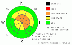
BOTTOM LINE
Danger by aspect and elevation on slopes approaching 35° or steeper.
(click HERE for tomorrow's danger rating)
|
Danger Rose Tutorial
|
Above treeline the avalanche danger is CONSIDERABLE on slopes steeper than about 35 degrees, especially those facing the north half of the compass with recent deposits of wind drifted snow. Human triggered avalanches are probable, natural avalanches possible. In addition, there’s a CONSIDERABLE danger of triggering avalanches today that have the possibility of breaking into weak layers of snow near the ground, creating a larger and more dangerous avalanche than you might expect.
At mid elevations the avalanche danger is MODERATE on steep wind drifted slopes and human triggered avalanches are possible.
While a LOW avalanche danger exists on slopes void of snow prior to today’s storm, be aware of steep slopes above and adjacent to you and avoid avalanche runout zones. |
|
|
CURRENT CONDITIONS |

|
Hang on to your hats! A strong, cold, vigorous storm is bearing down on the state and it looks like we’re in for a wild ride today. West and southwest winds increased late last night and are blowing 15-35 mph along the ridges with gusts in the 50’s and 60’s along the high peaks. Temperatures are still relatively mild, right around 30 degrees at the trailheads and in the upper 20’s at 10,000’. An inch of snow fell overnight, but that hasn’t really improved the riding and turning conditions much. With an average snow depth of about 20” at the upper elevations, it’s still pretty grim out there.
|
|
|
RECENT ACTIVITY |

|
No new activity reported. |
|
|
THREAT #1 |

|
| WHERE |
PROBABILITY |
SIZE |
TREND |

|
|
|
|
| |
|
|
Over the next
24
hours.
|
|
|
Today’s most obvious avalanche concern will be new snow avalanches and sensitive fresh wind drifts along the leeward side of ridges and terrain features. As the new snow starts stacking up and the winds howl you’ll want to avoid steep mid and upper elevation slopes, especially those facing the north half of the compass that had old snow prior to today’s storm. Today will be a day of changing weather and avalanche conditions, so you’ll need to pay attention to clues of unstable snow like cracking, collapsing and whoomphing sounds.
|
|
|
THREAT #2 |

|
| WHERE |
PROBABILITY |
SIZE |
TREND |
|
|
|
|
| |
|
|
Over the next
24
hours.
|
|
|
Once again this year we’re faced with a challenging snowpack and it’s going to get downright tricky out there the next few days. Remember- many early season avalanche accidents and close calls occur when we don’t think there’s enough snow to avalanche.
Until this morning the avalanche equation has been pretty straight forward because we lacked the key ingredient to make the snowpack dangerous- a slab. Now that the winds are cranking and there’s a storm at our door step the players are all coming together. As if we didn’t already have enough to think about, making conditions much different this year is the Thanksgiving rain crust. This crust is strong and stout, but unfortunately this false sense of strength is what concerns me most. Weak, sugary faceted snow developed underneath the crust and all of our snowpit tests indicate an inherently dangerous snowpack. In addition, you’ll be able to trigger avalanches from a distance and on low angle slopes, so think about steep slopes above and adjacent to where you’re riding. Finally, today’s avalanches have the potential to break into older snow near the ground, creating a deep, wide, more dangerous slide than you might expect given the lack of snow. |
|
|
MOUNTAIN WEATHER |

|
Winter is roaring back with a vengeance today. Strong prefrontal winds out of the west and southwest will be nuking along the upper elevation ridges and peaks. Expect hourly averages in the 30’s with gusts in the 60’s and 70’s at the most exposed locations. The storm should be here just after sunrise ushering in a period of heavy snow. Winds veer to the northwest after frontal passage and remain strong throughout the day. Looks like snow totals will be near a foot by the end of the day with another 4”-6” expected overnight. Temperatures crash tonight with lows near zero. Sunday the storm winds down, but we should still see a scattered snow shower or two with high temperatures in the low teens. Unsettled weather is on tap for most of the week.
|
|
|
GENERAL ANNOUNCEMENTS |
Remember- your observations help to save other riders lives. So if you see or trigger any avalanches please let me know what your seeing. You can reach me at 801-231-2170 or craig@utahavalanchecenter.org
While it's quiet, now is a great time to schedule a free avalanche awareness class for your group or club. You can reach me at 801-231-2170 or craig@utahavalanchecenter.org for more details.
The information in this advisory expires 24 hours after the date and time posted. I'll update this advisory by 7:00 am on Sunday Dec. 14, 2008. |
|
|
This information does not apply to developed ski areas or highways where avalanche control is normally done. This advisory is from the U.S.D.A. Forest Service, which is solely responsible for its content. This advisory describes general avalanche conditions and local variations always occur. |
|
This advisory provided by the USDA Forest Service, in partnership with:
The Friends of the Utah Avalanche Center, Utah Division of State Parks and Recreation, Utah Division of Emergency Management, Salt Lake County, Salt Lake Unified Fire Authority and the friends of the La Sal Avalanche Center. See our Sponsors Page for a complete list. |
