BOTTOM LINE
Danger by aspect and elevation on slopes approaching 35° or steeper.
(click HERE for tomorrow's danger rating)
|
Danger Rose Tutorial
|
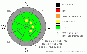
While the avalanche danger is generally LOW, fresh wind drifts formed along the leeward side of upper elevation ridges remain sensitive to the additional weight of a person today. These will be isolated to terrain above treeline with an easterly componant to their aspect. |
|
|
CURRENT CONDITIONS |

|
High pressure building over the region the next few days will usher in light winds, warm temperatures and mostly sunny skies. Temperatures remained relatively warm overnight and are currently in the upper 20’s at 10,000’ and in the low to mid 20’s at the trailheads. Winds are generally light and northwesterly, blowing 5-15 mph at most locations, though a few gusts in the 20’s and 30’s are being reported along the upper elevation ridges. The mid week storm brought in a much needed fresh coat of new paint for the mountains, but with storm totals only in the 3”-4” range riding and turning conditions remain limited to smooth, grassy, rock free slopes.
|
|
|
RECENT ACTIVITY |

|
No avalanche activity reported or observed. |
|
|
THREAT #1 |

|
| WHERE |
PROBABILITY |
SIZE |
TREND |

|
|
|
|
| |
|
|
Over the next
24
hours.
|
|
|
For the next few days the avalanche conditions will be pretty straight forward. Pockety wind slabs isolated to the leeward side of upper elevation ridges will still be sensitive to the weight of a rider. The coverage has improved somewhat with the mid week storm, so as you start to nose into steeper terrain you’ll want to avoid any fresh deposits of wind drifted snow.
In the bigger picture, while our weakening shallow snowpack doesn’t pose much of a problem today it’s quite complex and made up of several unusual layers that could make things tricky once winter decides to kick into gear. The most obvious curve ball is the rain crust that developed last weekend that in some drainages, seems to be breaking down and in other locations remains strong and will take some weight before it fails. With a storm slated to move through the region early next week, this would be a good weekend to get after it and mentally map out some of these trends.
|
|
|
MOUNTAIN WEATHER |

|
It looks like a spectacular weekend in the mountains with warm temperatures and light winds expected through early Sunday. Today’s highs at 8,000’ should reach into the mid 40’s and at 10,000’ near 38 degrees. Overnight lows dip into the mid 20’s. West and northwest winds remain fairly light at most locations today, blowing 5-15 mph, but gusts in the 30’s are still expected along the high peaks. Sunday we should see increasing high clouds throughout the day as a cold storm system moves in from the northwest. It’s a quick hitter that starts to affect the region midday Monday and it looks like storm totals in the 6”-8” range seem reasonable. Clearing and quiet weather is on tap for late Tuesday and Wednesday with another weak cold front on Thursday. Gazing into the weather forecast crystal ball, the computer models hint at the possibility for a big pattern change next weekend.
|
|
|
GENERAL ANNOUNCEMENTS |
Remember- your observations help to save other riders lives. So if you see or trigger any avalanches please let me know what your seeing. You can reach me at 801-231-2170 or craig@utahavalanchecenter.org
While it's quiet, now is a great time to schedule a free avalanche awareness class for your group or club. You can reach me at 801-231-2170 or craig@utahavalanchecenter.org for more details.
The information in this advisory expires 24 hours after the date and time posted. I'll update this advisory by 7:00 am on Sunday Dec. 7, 2008. |
|
|
This information does not apply to developed ski areas or highways where avalanche control is normally done. This advisory is from the U.S.D.A. Forest Service, which is solely responsible for its content. This advisory describes general avalanche conditions and local variations always occur. |
|
This advisory provided by the USDA Forest Service, in partnership with:
The Friends of the Utah Avalanche Center, Utah Division of State Parks and Recreation, Utah Division of Emergency Management, Salt Lake County, Salt Lake Unified Fire Authority and the friends of the La Sal Avalanche Center. See our Sponsors Page for a complete list. |
