SPECIAL ANNOUNCEMENT |
|
|
|
BOTTOM LINE
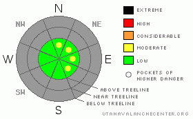
Danger by aspect and elevation on slopes approaching 35° or steeper.
(click HERE for tomorrow's danger rating)
|
Danger Rose Tutorial
|
While the avalanche danger is generally LOW, slabs formed along the leeward side of upper elevation ridges are sensitive to the additional weight of a person today. These will be isolated to terrain above treeline with an easterly componant to the aspect. |
|
|
CURRENT CONDITIONS |

|
A cold northwest flow is producing a few lingering snow showers over the region this morning in the wake of yesterday’s quick hitting system. Storm totals are just about 3” at the upper elevations with a trace or so falling at the trailheads. West and northwest winds began blowing strong late Tuesday afternoon, averaging 25 mph with gusts in the 60’s along the high ridges. They’ve relaxed somewhat this morning, now blowing in the 10-20 mph range. Temperatures are in the low 20’s at 10,000’ and near 28 degrees at the trailheads. Right now the riding and turning conditions are best described as unique, and not in a good way. With hardly any low or mid elevation snowpack travel is pretty much limited to the upper elevations where total snow depths only average 12"-16".
|
|
|
RECENT ACTIVITY |

|
No avalanche activity reported or observed. |
|
|
THREAT #1 |

|
| WHERE |
PROBABILITY |
SIZE |
TREND |
|
|
|
|
| |
|
|
Over the next
24
hours.
|
|
|
As if our variable snowpack isn’t enough to deal with this year, nature really threw us a curve ball over the weekend, creating a widespread rain crust on just about every slope out there. Once it’s buried, this crust could come back to haunt us and it’s something to keep an eye on over the course of the winter. For right now though, the most obvious avalanche danger is pretty basic. Most of the new snow would’ve bonded poorly to the rain crust and recently formed wind drifts will be sensitive the weight of a person. Today’s slabs are easy to detect and isolated to the leeward side of upper elevation ridges, chutes and gullies especially those with an easterly component to their aspect. With lots of obstacles out there to slam into, triggering even a small slide could result in a body beating experience.
|
|
|
MOUNTAIN WEATHER |

|
Plenty of lingering clouds and a few snow showers are on tap for the area today as we remain under a moist, northwesterly flow. We might be able to squeeze another inch of snow out of this system before it exits the region. Temperatures won’t vary much today with highs at 10,000’ in the low to mid 20’s and at 8,000’ near 30 degrees. Overnight lows will be in the mid teens. Northwest will blow 10-20 mph at most locations, with gusts in the 40’s along the high exposed peaks and ridges. A weakening storm brushes the northern half of the state for Thursday, producing clouds and a few flurries and then we’re back to high and dry weather for the weekend. The computer models fantasize about a change in the weather pattern next week sometime, but they’re still arguing about the timing. I’ll have a better handle on this developing news for Saturday’s update.
Plenty of lingering clouds and a few snow showers are on tap
for the area today as we remain under a moist, northwesterly flow. We might be
able to squeeze another inch of snow out of this system before it exits the
region. Temperatures won’t vary much today with highs at 10,000’ in the low to
mid 20’s and at 8,000’ near 30 degrees. Overnight lows will be in the mid
teens. Northwest will blow 10-20 mph at most locations, with gusts in the 40’s
along the high exposed peaks and ridges. A weakening storm brushes the northern
half of the state for Thursday, producing clouds and a few flurries and then we’re
back to high and dry weather for the weekend. The computer models fantasize
about a change in the weather pattern next week sometime, but they’re still arguing
about the timing. I’ll have a better handle on this developing news for
Saturday’s update.
|
|
|
GENERAL ANNOUNCEMENTS |
Remember- your observations help to save other riders lives. So if you see or trigger any avalanches please let me know what your seeing. You can reach me at 801-231-2170 or craig@utahavalanchecenter.org
While it's quiet, now is a great time to schedule a free avalanche awareness class for your group or club. You can reach me at 801-231-2170 or craig@utahavalanchecenter.org for more details.
The information in this advisory expires 24 hours after the date and time posted. I'll update this advisory by 7:00 am on Saturday Dec. 6, 2008. |
|
|
This information does not apply to developed ski areas or highways where avalanche control is normally done. This advisory is from the U.S.D.A. Forest Service, which is solely responsible for its content. This advisory describes general avalanche conditions and local variations always occur. |
|
This advisory provided by the USDA Forest Service, in partnership with:
The Friends of the Utah Avalanche Center, Utah Division of State Parks and Recreation, Utah Division of Emergency Management, Salt Lake County, Salt Lake Unified Fire Authority and the friends of the La Sal Avalanche Center. See our Sponsors Page for a complete list. |
