BOTTOM LINE
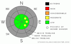
Danger by aspect and elevation on slopes approaching 35° or steeper.
(click HERE for tomorrow's danger rating)
|
Danger Rose Tutorial
|
While the avalanche danger is generally LOW, slabs formed along the leeward side of upper elevation ridges today may be sensitive to the additional weight of a person. |
|
|
CURRENT CONDITIONS |

|
A moist northerly flow is keeping clouds and a flurry or two over the region this morning. The big news is the west and northwest winds. They started cranking along the high peaks and ridges late yesterday at about 6:00 in the evening and have blown steadily through the night with hourly averages in the 30’s and gusts in the mid to upper 50’s. Mid elevations are a little more reasonable, blowing in the 15-30 mph range. Yet another mighty inch of snow fell overnight bringing our storm totals to 2” in the past 24 hours. Temperatures are in the low 20’s at 10,000’ and near 28 degrees at the trailheads. With only a foot of heat crusted, wind worked snow on the ground, there's barely enough base to even ride on grassy slopes and our rock filled terrain is absolutely out of the question. No matter how you cut it, it’s still pretty grim out there.
|
|
|
RECENT ACTIVITY |

|
No avalanche activity reported or observed. |
|
|
THREAT #1 |

|
| WHERE |
PROBABILITY |
SIZE |
TREND |

|
|
|
|
| |
|
|
Over the next
24
hours.
|
|
|
Our early season snowpack is rapidly deteriorating and we’re developing plenty of weak sugary facets both near the ground and at the snow surface. Of course, this doesn’t bode well for us once it starts snowing or the wind blows and a slab develops on top of this mess. Speaking of wind, last nights wind event certainly formed shallow slabs along the leeward side of upper elevation ridgelines, peaks and gullies. While isolated to a small portion of the terrain out there, these fresh wind drifts will be sensitive to the additional weight of a person. Today’s avalanches are mostly shallow and manageable but remember- going for a ride in even a small avalanche this time of year and slamming into a trauma inducing rock or stump will definitely ruin your holiday weekend.
|
|
|
MOUNTAIN WEATHER |

|
A ridge will build off the west coast today placing Utah under a moist and strong northerly flow. We can expect mostly cloudy skies, cool temperatures and burly winds. Highs at 8,000' will be in the low 30's and at 10,000' in the mid 20's. Overnight lows should be around 22 degrees. Northwest winds will continue be an issue through this afternoon, blowing 15-30 mph with gusts in the mid 50's along the high ridges. Drier weather returns for Sunday and Monday with the possibility for some light snow developing sometime late Tuesday. Not a big storm, but it might help to freshen the rocks up a little bit.
|
|
|
GENERAL ANNOUNCEMENTS |
Remember- your observations help to save other riders lives. So if you see or trigger any avalanches please let me know what your seeing. You can reach me at 801-231-2170 or craig@utahavalanchecenter.org
While it's quiet, now is a great time to schedule a free avalanche awareness class for your group or club. You can reach me at 801-231-2170 or craig@utahavalanchecenter.org for more details.
The information in this advisory expires 24 hours after the date and time posted. I'll update this advisory by 7:00 am on Sunday Nov. 30, 2008. |
|
|
This information does not apply to developed ski areas or highways where avalanche control is normally done. This advisory is from the U.S.D.A. Forest Service, which is solely responsible for its content. This advisory describes general avalanche conditions and local variations always occur. |
|
This advisory provided by the USDA Forest Service, in partnership with:
The Friends of the Utah Avalanche Center, Utah Division of State Parks and Recreation, Utah Division of Emergency Management, Salt Lake County, Salt Lake Unified Fire Authority and the friends of the La Sal Avalanche Center. See our Sponsors Page for a complete list. |
