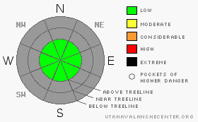
BOTTOM LINE
Danger by aspect and elevation on slopes approaching 35° or steeper.
(click HERE for tomorrow's danger rating)
|
|
|
|
CURRENT CONDITIONS |

|
A veil of high, thin clouds moved into the region last night keeping temperatures rather mild for this time of year. Currently it's in the low 20's at 10,000' and near 27 degrees at the trailhead elevations. Winds are light and southerly, blowing 5-15 mph at most locations with an occasional gust in the low 20's along the high ridgelines. No new snow has fallen in over a week and it's getting downright discouraging out there. With only a foot of heat crusted, wind worked snow on the ground, there's barely enough base to even ride on grassy slopes. |
|
|
RECENT ACTIVITY |

|
No avalanche activity reported or observed. |
|
|
THREAT #1 |

|
| WHERE |
PROBABILITY |
SIZE |
TREND |

|
|
|
|
| |
|
|
Over the next
24
hours.
|
|
|
While most of our snowpack is capped with wind and sun crusts, there may be an isolated old wind slab or two along the high ridgelines that could still be sensitive to the weight of a person. However, with the lack of a uniform snowpack the chances of slamming into a trauma-inducing rock or stump greatly outweigh the chances of triggering an avalanche right now. |
|
|
MOUNTAIN WEATHER |

|
A weak cold front slides through the area late today into Sunday, offering cooler temperatures and a flurry or two of snow. Westerly winds increase later this morning and should gust in the 20's and 30's along the ridges. High temperatures will be in the low 30's at 8,000' and mid 20's at 10,000'. Overnight lows dive into the upper teens. Clearing and a little cooler for Sunday before we return to warm, high pressure for early in the week. A change in the weather pattern is slated for Wednesday night with a return to wet unsettled weather for the upcoming holiday. I'll have more details on tomorrow's advisory. |
|
|
GENERAL ANNOUNCEMENTS |
Remember- your observations help to save other rides lives. So if you see or trigger any avalanches please let me know what your seeing. You can reach me at 801-231-2170 or craig@utahavalanchecenter.org
While it's quiet, now is a great time to schedule a free avalanche awareness class for your group or club. You can reach me at 801-231-2170 or craig@utahavalanchecenter.org for more details.
The information in this advisory expires 24 hours after the date and time posted, but will be updated by 7:00 am on Sunday Nov. 23, 2008. |
|
|
This information does not apply to developed ski areas or highways where avalanche control is normally done. This advisory is from the U.S.D.A. Forest Service, which is solely responsible for its content. This advisory describes general avalanche conditions and local variations always occur. |
|
This advisory provided by the USDA Forest Service, in partnership with:
The Friends of the Utah Avalanche Center, Utah Division of State Parks and Recreation, Utah Division of Emergency Management, Salt Lake County, Salt Lake Unified Fire Authority and the friends of the La Sal Avalanche Center. See our Sponsors Page for a complete list. |