SPECIAL ANNOUNCEMENT |
 |
Thank you to everyone who participated in the second annual UAC/Brewvies fundraiser this week... it was a blast and a huge success! I'd especially like to thank the athletes from Boondockers and Thunderstruck for providing the entertainment along with the following sponsors who donated funds offsetting the food and venue costs. A big thanks to Brewvies Cinema, Rocky Mountain Sledders, The Edge Motorsports, The Utah Snowmobile Association, Rob Smith and National City Mortgage, Rocky Mountain Snowmobile of Orem, Black Diamond Products, Net Sleds and Klim. |
|
|
BOTTOM LINE
Danger by aspect and elevation on slopes approaching 35° or steeper.
(click HERE for tomorrow's danger rating)
|
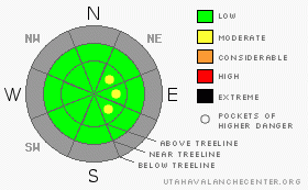
Danger Rose Tutorial
|
The avalanche danger is generally LOW though there may be a rogue wind slab or two lurking on steep upper elevation leeward slopes, especially those with an easterly component to their aspect. |
|
|
CURRENT CONDITIONS |

|
High pressure is strengthening and so are the temperature inversions. Under clear skies temperatures are pretty balmy for this time of year, in the low 30's at most mid and upper elevation locations, just about the same as in Salt Lake City this morning. Even Lily Lake which is usually brutally cold is a comfortable 22 degrees. Northwest winds picked up around 2:00 this morning and are blowing in the 10-20 mph range along the upper elevation ridges. Total snow depths around the range are pretty grim at best averaging 12"-16". To add insult to injury, the mid week rain/rime event put a nice glaze on nearly all snow covered slopes. Riding and turning conditions are limited to smooth, grassy, rock-free slopes. Before the snow begins to fly in earnest, take some time and go through your rescue gear- avalanche beacons, shovels, probes- and make sure everything is in good working order. |
|
|
RECENT ACTIVITY |

|
No new avalanches to report. |
|
|
THREAT #1 |

|
| WHERE |
PROBABILITY |
SIZE |
TREND |
|
|
|
|
| |
|
|
Over the next
24
hours.
|
|
|
There's not a whole lot going on in the avalanche department at this point in time, but there may be an isolated wind slab or two which formed as a result of Thursday's vicious wind event. While things were quiet down low, winds howled at the upper elevations with hourly averages in the 30's and 40's, gusting to 80 mph at some exposed ridgeline locations. Of course nuking winds like these always find enough snow to blow around and form stiff, pockety slabs. While not widespread and limited to upper elevation terrain, keep in mind they could still be sensitive to the additional weight of a person. With a shallow snowpack in place and lots of obstacles to slam into, even a small avalanche could take you for a body bruising ride. |
|
|
MOUNTAIN WEATHER |

|
High pressure along the west coast will build inland resulting in a continued warming trend through Monday with 8,000' highs near 50 degrees and at 10,000' in the mid 40's. Overnight lows will be near 30 degrees. Winds remain out of the northwest blowing 10-20 mph with an occasional gust in the mid 20's along the highest ridges. The computer models suggest a change in the weather pattern around Thursday which could open the door to a series of incoming storms for next weekend. A little too early to hedge any bets on, but I'll keep you updated as things develop. |
|
|
GENERAL ANNOUNCEMENTS |
Remember- your observations help to save other rides lives. So if you see or trigger any avalanches please let me know what your seeing. You can reach me at 801-231-2170 or craig@utahavalanchecenter.org While it's quiet, now is a great time to schedule a free avalanche awareness class for your group or club. You can reach me at 801-231-2170 or craig@utahavalanchecenter.org for more details. With no storms in sight for the near future, I'll continue to update this advisory on a weekend basis until the season kicks in. |
|
|
This information does not apply to developed ski areas or highways where avalanche control is normally done. This advisory is from the U.S.D.A. Forest Service, which is solely responsible for its content. This advisory describes general avalanche conditions and local variations always occur. |
|
This advisory provided by the USDA Forest Service, in partnership with:
The Friends of the Utah Avalanche Center, Utah Division of State Parks and Recreation, Utah Division of Emergency Management, Salt Lake County, Salt Lake Unified Fire Authority and the friends of the La Sal Avalanche Center. See our Sponsors Page for a complete list. |
