SPECIAL ANNOUNCEMENT |
 |
Thank you to everyone who participated in the second annual UAC/Brewvies fundraiser this week... it was a blast and a huge success! I'd especially like to thank the athletes from Boondockers and Thunderstruck for providing the entertainment along with the following sponsors who donated funds offsetting the food and venue costs. A big thanks to Brewvies Cinema, Rocky Mountain Sledders, The Edge Motorsports, The Utah Snowmobile Association, Rob Smith and National City Mortgage, Rocky Mountain Snowmobile of Orem, Black Diamond Products, Net Sleds and Klim. |
|
|
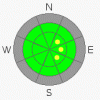
BOTTOM LINE
Danger by aspect and elevation on slopes approaching 35° or steeper.
(click HERE for tomorrow's danger rating)
|

Danger Rose Tutorial
|
The avalanche danger is generally LOW though there may be a rogue wind slab or two lurking on steep upper elevation leeward slopes, especially those with an easterly component to their aspect. |
|
|
CURRENT CONDITIONS |

|
High pressure is gradually strengthening and under clear skies temperatures are in the low to mid 20's at most mid and upper elevation locations. A few exceptions are the usual suspects where cold air pools such as Lily Lake which is still in the low teens. Northwest winds are blowing in the 10-20 mph range along the upper elevation ridges. Total snow depths around the range are pretty grim at best averaging 12"-16". To add insult to injury, the mid week rain/rime event put a nice glaze on nearly all snow covered slopes. Riding and turning conditions are limited to smooth, grassy, rock-free slopes. |
|
|
RECENT ACTIVITY |

|
No new avalanches to report. |
|
|
THREAT #1 |

|
| WHERE |
PROBABILITY |
SIZE |
TREND |
|
|
|
|
| |
|
|
Over the next
24
hours.
|
|
|
There's not a whole lot going on in the avalanche department at this point in time, but there may be an isolated wind slab or two which formed as a result of Thursday's vicious wind event. While things were quiet down low, winds howled at the upper elevations with hourly averages in the 30's and 40's, gusting to 80 mph at some exposed ridgeline locations. Of course nuking winds like these always find enough snow to blow around and form stiff, pockety slabs. While not widespread and limited to upper elevation terrain, keep in mind they could still be sensitive to the additional weight of a person. With a shallow snowpack in place and lots of obstacles to slam into, even a small avalanche could take you for a body bruising ride. |
|
|
MOUNTAIN WEATHER |

|
High pressure builds through Monday giving us mostly sunny skies, decreasing winds and warming temperatures. Highs today will reach into the low 40's at 8,000' and right around freezing at 10,000'. Overnight temperatures drop into the upper 20's. Winds will remain out of the northwest, blowing 10-20 mph with an occasional gust in the mid 20's, then die down to less than 15 mph overnight. Looks like we remain high and dry throughout the week with a chance of snow developing late next week. |
|
|
GENERAL ANNOUNCEMENTS |
I'll be giving a free avalanche awareness talk today at Triple S Polaris in Ogden at 2:00. They're located at 2339 S 1900 W. With no storms in sight for the near future, I'll continue to update this advisory on a weekend basis until the season kicks in. |
|
|
This information does not apply to developed ski areas or highways where avalanche control is normally done. This advisory is from the U.S.D.A. Forest Service, which is solely responsible for its content. This advisory describes general avalanche conditions and local variations always occur. |
|
This advisory provided by the USDA Forest Service, in partnership with:
The Friends of the Utah Avalanche Center, Utah Division of State Parks and Recreation, Utah Division of Emergency Management, Salt Lake County, Salt Lake Unified Fire Authority and the friends of the La Sal Avalanche Center. See our Sponsors Page for a complete list. |
