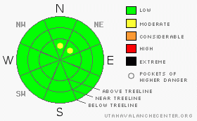
BOTTOM LINE
Danger by aspect and elevation on slopes approaching 35° or steeper.
(click HERE for tomorrow's danger rating)
|
Danger Rose Tutorial
|
Except for a wind slab or two on the leeward side of upper elevation ridges and gullies, the avalanche danger is generally LOW and human triggered avalanches are unlikely. |
|
|
CURRENT CONDITIONS |

|
A series of recent storms deposited up to two feet of snow at the upper elevations. The chances of triggering an avalanche are limited to shady north facing slopes above tree line, especially those that had pre-existing snow prior to this weeks storm. |
|
|
MOUNTAIN WEATHER |

|
Mostly sunny skies and mild temperatures are on tap for today with highs reaching into the low 40's. Southwesterly winds increase late in the day, pushing a moist storm system into the region. Snow is likely late tonight through Monday, but there's still some uncertainty right now how things will pan out. |
|
|
GENERAL ANNOUNCEMENTS |
Join us for dinner and a movie this Thursday Nov. 13th at Brewvies Cinema in Salt Lake City for the second annual Boondockers/Thunderstruck premier. Festivities start at 6:30 (food and drink) with the movies rolling at 7:00. Tickets are $10.00 and all proceeds go to the Friends of the UAC for snowmobile specific avalanche awareness programs. |
|
|
This information does not apply to developed ski areas or highways where avalanche control is normally done. This advisory is from the U.S.D.A. Forest Service, which is solely responsible for its content. This advisory describes general avalanche conditions and local variations always occur. |
|
This advisory provided by the USDA Forest Service, in partnership with:
The Friends of the Utah Avalanche Center, Utah Division of State Parks and Recreation, Utah Division of Emergency Management, Salt Lake County, Salt Lake Unified Fire Authority and the friends of the La Sal Avalanche Center. See our Sponsors Page for a complete list. |
