25th Annual Black Diamond Fall Fundraising Party
Thursday, September 13; 6:00-10:00 PM; Black Diamond Parking Lot
25th Annual Black Diamond Fall Fundraising Party
Thursday, September 13; 6:00-10:00 PM; Black Diamond Parking Lot
| Advisory: Skyline Area Mountains | Issued by Brett Kobernik for Saturday - March 24, 2018 - 6:43am |
|---|

|
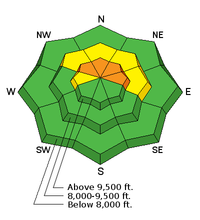
bottom line The majority of the terrain has a LOW to MODERATE avalanche danger. There is a chance that a person could trigger an avalanche that breaks over 4 feet deep to the ground on the steep upper elevation slopes that face northwest, north and east. Because of the high consequence, the danger is still CONSIDERABLE there.
|
 |
current conditions The Skyline received rain up to at least 10,000' Thursday afternoon and night. The rain changed to snow down to about 8000'. About 4" of very dense snow accumulated in the higher terrain. It was fairly windy during the storm so the new snow is deeper in some areas and shallower in others. You'll find a fairly stout rain crust under the new snow. The snowpack is wet and unconsolidated below the rain crust in elevations below about 9000'. |
| type | aspect/elevation | characteristics |
|---|

|
|
LIKELIHOOD
 LIKELY
UNLIKELY
SIZE
 LARGE
SMALL
TREND
 INCREASING DANGER
SAME
DECREASING DANGER
|
|
description
The overall stability of the snowpack in the upper elevation more northerly facing terrain has improved over the last week. Settlement of the snowpack after last week's large storm has increased the strength of the mid portion of the snowpack. The new stout rain crust is also helping tie the snowpack together. The problem is that the weak faceted snow near the ground is still weak enough to cause concern. Chances for triggering a deep avalanche are not very likely but the consequence if you do is huge. The most likely spots to trigger something is in the more shallow spots especially around rocky terrain above 9500' in elevation that face northwest, north and east. |
 |
weather It looks like we have a nice day in store today with partly cloudy skies and mild temperatures. Ridge top high temperatures will be in the mid 30s and the wind should be moderate in speed from the southwest. We'll see partly cloudy skies again on Sunday with a minor storm moving through Sunday night that should bring a few inches of snow. We stay in a cool unsettled northerly flow for most of next week with no significant snow anticipated. |
| general announcements Support the Utah Avalanche Center through your everyday shopping. DETAILS HERE We will publish full detailed advisories Saturday and Sunday mornings by 7am. We will also be publishing basic avalanche danger ratings & info during the week. If you are getting out into the mountains, we love to hear from you! You can SUBMIT OBSERVATIONS ONLINE or EMAIL US If you would like to have avalanche advisories emailed to you, SIGN UP HERE We can provide basic avalanche awareness presentations for your school, group or club. To enquire, CLICK HERE |


