25th Annual Black Diamond Fall Fundraising Party
Thursday, September 13; 6:00-10:00 PM; Black Diamond Parking Lot
25th Annual Black Diamond Fall Fundraising Party
Thursday, September 13; 6:00-10:00 PM; Black Diamond Parking Lot
| Advisory: Skyline Area Mountains | Issued by Brett Kobernik for Sunday - March 18, 2018 - 7:00am |
|---|

|
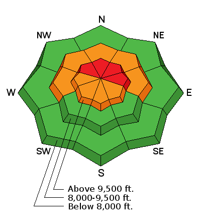
bottom line The avalanche danger is HIGH in the upper elevation steep slopes that face northwest, north and east. Human triggered and natural avalanches are almost certain on these slopes today. Travel in avalanche terrain is not recommended which means staying off of and out from underneath steep slopes. Here's the deal, because of poor visibility today, not many people are going to be in the high elevation avalanche terrain today so I'm not expecting to hear of trouble. The storm clears out and the weather on Monday and Tuesday looks really nice. However, avalanche conditions will remain dangerous Monday and Tuesday. These are the most likely days for someone to get caught in an avalanche.
|
 |
avalanche warning THE FOREST SERVICE UTAH AVALANCHE CENTER IN SALT LAKE CITY HAS ISSUED A BACKCOUNTRY AVALANCHE WARNING. * TIMING…IN EFFECT THROUGH 6PM MST SUNDAY, MARCH 18. * AFFECTED AREA…FOR THE MOUNTAINS OF THE MANTI SKYLINE AND THE CENTRAL MOUNTAINS OF UTAH INCLUDING THE FISH LAKE MOUNTAINS. * AVALANCHE DANGER…THE AVALANCHE DANGER FOR THE WARNING AREA WILL BE HIGH SATURDAY AND SUNDAY. * IMPACTS…TRAVEL IN AVALANCHE TERRAIN IS NOT RECOMMENDED. WEAK SNOW NEAR THE GROUND HAS BEEN OVERLOADED WITH NEW WIND BLOWN SNOW FROM THE LAST FEW DAYS. LARGE AVALANCHES BREAKING TO THE GROUND ARE LIKELY. HUMAN TRIGGERED AVALANCHES ARE VERY LIKELY TODAY AND SUNDAY. STAY OFF OF AND OUT FROM UNDERNEATH STEEP SLOPES. AVALANCHES CAN BE TRIGGERED FROM A DISTANCE EVEN FROM BELOW A STEEP SLOPE. |
 |
current conditions The Skyline picked up about 5 inches of new snow in the last 24 hours. Wind has shifted around to the northwest and is quite light in speed. Mountain temperatures are in the teens. |
| type | aspect/elevation | characteristics |
|---|

|
|
LIKELIHOOD
 LIKELY
UNLIKELY
SIZE
 LARGE
SMALL
TREND
 INCREASING DANGER
SAME
DECREASING DANGER
|
|
description
It's very simple today. You can't trust any steep upper elevation slope that faces northwest, north or east. The new snow continues to stress the deeply buried weak snow and it is likely to collapse and cause avalanches. There have been reports of collapsing, cracking and human triggered avalanches over the last few days. With additional weight from the current storm, avalanches are even more likely. |
 |
weather Snow will continue today and we might pick up another 3 to 6 inches of snow. Northwest wind is expected to increase to strong speeds by this afternoon. The strong wind will transport snow adding additional weight to many slopes. This will likely be the straw that breaks the camels back for these slopes. High temperatures will remain in the teens. The storm will start to clear out later today. Monday and Tuesday look like mostly sunny days with warming mountain temperatures. |
| general announcements Support the Utah Avalanche Center through your everyday shopping. DETAILS HERE We will publish full detailed advisories Saturday and Sunday mornings by 7am. We will also be publishing basic avalanche danger ratings & info during the week. If you are getting out into the mountains, we love to hear from you! You can SUBMIT OBSERVATIONS ONLINE or EMAIL US If you would like to have avalanche advisories emailed to you, SIGN UP HERE We can provide basic avalanche awareness presentations for your school, group or club. To enquire, CLICK HERE |


