25th Annual Black Diamond Fall Fundraising Party
Thursday, September 13; 6:00-10:00 PM; Black Diamond Parking Lot
25th Annual Black Diamond Fall Fundraising Party
Thursday, September 13; 6:00-10:00 PM; Black Diamond Parking Lot
| Advisory: Skyline Area Mountains | Issued by Brett Kobernik for Sunday - February 25, 2018 - 6:20am |
|---|


|
bottom line The avalanche danger is HIGH on steep slopes above 9500' that face northwest, north and east. Natural avalanches may occur during the day today with additional wind drifted snow. Human triggered avalanches are almost certain on these slopes. It is possible to trigger avalanches from a distance so it is important not only to avoid being on these slopes but also avoid being below them.
|
 |
current conditions The Skyline received about 7 inches of new snow overnight. The west northwest wind has increased slightly overnight into the moderate speed range. Enough so to transport the new snow. Mountain temperatures are in the upper single digits. Riding conditions are excellent but be careful! This can often make us lose track of the avalanche danger. |
 |
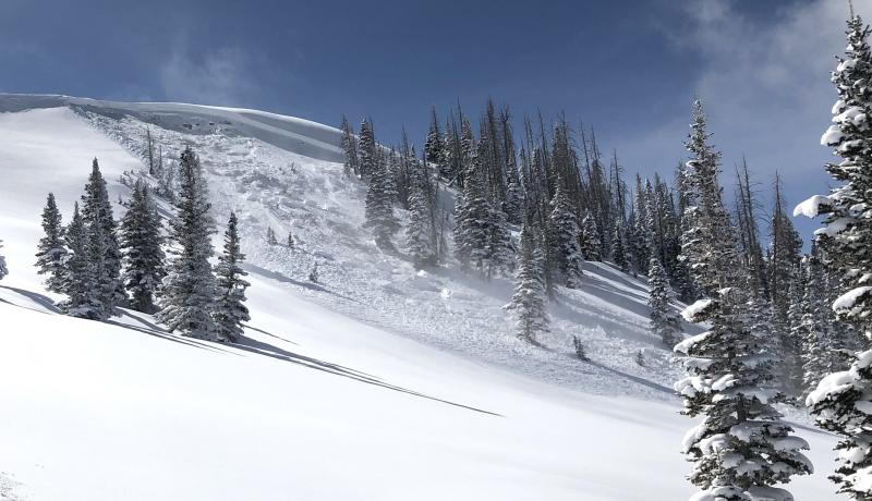
recent activity There was one skier triggered avalanche on Saturday. It was "remotely triggered", or triggered from a distance. No one was caught or injured. There is little doubt that the weak layer was old weak snow from earlier in the season. It was the north facing slope at about 10,000' in elevation on Knob Mountain. DETAILS HERE
PHOTO: Richard Stum During my day on Saturday in the Ephraim Canyon vicinity, I found a number of older avalanches from over the last week that all broke into the old weak faceted snow. |
| type | aspect/elevation | characteristics |
|---|

|

|
LIKELIHOOD
 LIKELY
UNLIKELY
SIZE
 LARGE
SMALL
TREND
 INCREASING DANGER
SAME
DECREASING DANGER
|
|
description
There is no mystery to what is going on. Sporadic human triggered avalanches continue to occur. People continue to experience collapsing (whoomping!) of the snowpack. Snowpit tests continue to show poor results. All of this is being caused by weak sugary faceted snow from earlier in the season which is now buried and can't support the newer snow. On top of that, we just added 7 more inches of snow along with some wind that will have drifted the new snow into deeper drifts which adds even more weight. |
 |
weather The storm will start to clear out this morning and we should see sunny skies as the day goes on. West northwest wind will be in the moderate speed category. It will probably be windy enough to drift snow along the upper ridges. Mountain temperatures should get up into the upper teens today. The weather looks a little unsettled during the week with a small storm moving through early in the week and a more significant storm moving through at the end of the week. |
| general announcements Support the Utah Avalanche Center through your everyday shopping. DETAILS HERE We will publish full detailed advisories Saturday and Sunday mornings by 7am. We will also be publishing basic avalanche danger ratings & info during the week. If you are getting out into the mountains, we love to hear from you! You can SUBMIT OBSERVATIONS ONLINE or EMAIL US If you would like to have avalanche advisories emailed to you, SIGN UP HERE We can provide basic avalanche awareness presentations for your school, group or club. To enquire, CLICK HERE |