25th Annual Black Diamond Fall Fundraising Party
Thursday, September 13; 6:00-10:00 PM; Black Diamond Parking Lot
25th Annual Black Diamond Fall Fundraising Party
Thursday, September 13; 6:00-10:00 PM; Black Diamond Parking Lot
| Advisory: Skyline Area Mountains | Issued by Brett Kobernik for Monday - February 19, 2018 - 6:15am |
|---|


|
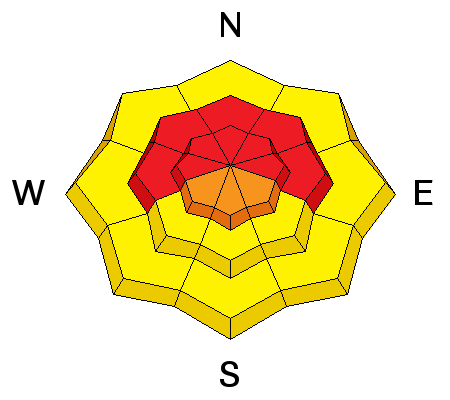
bottom line The avalanche danger is HIGH today. Backcountry travel is not recommended. Stay off and out from underneath steep slopes. Some avalanches may run long distances so it is very important to make sure you are not at the bottom of any large avalanche path.
|
 |
current conditions It started snowing at about 2am and we're up to around 6 inches so far. Southwest wind is still strong. Temperatures have been dropping and are in the teens. |
| type | aspect/elevation | characteristics |
|---|

|
|
LIKELIHOOD
 LIKELY
UNLIKELY
SIZE
 LARGE
SMALL
TREND
 INCREASING DANGER
SAME
DECREASING DANGER
|
|
description
It's no mystery what's going on. We have had weak snow sitting around for most of the winter and now we're finally stacking new snow on top of it. There have been human triggered and large natural avalanches over the last few days. With more snow anticipated today, more natural avalanches are expected. |
 |
weather I'm expecting snow for most of the day which could add another foot to our snowpack. Temperatures will continue to drop from the teens into the single digits. Wind will shift northwest and start to slow in speed this morning sometime. Snowfall looks like it will taper off this evening. |
| general announcements Support the Utah Avalanche Center through your everyday shopping. DETAILS HERE We will publish full detailed advisories Saturday and Sunday mornings by 7am. We will also be publishing basic avalanche danger ratings & info during the week. If you are getting out into the mountains, we love to hear from you! You can SUBMIT OBSERVATIONS ONLINE or EMAIL US If you would like to have avalanche advisories emailed to you, SIGN UP HERE We can provide basic avalanche awareness presentations for your school, group or club. To enquire, CLICK HERE |


