25th Annual Black Diamond Fall Fundraising Party
Thursday, September 13; 6:00-10:00 PM; Black Diamond Parking Lot
25th Annual Black Diamond Fall Fundraising Party
Thursday, September 13; 6:00-10:00 PM; Black Diamond Parking Lot
| Advisory: Skyline Area Mountains | Issued by Brett Kobernik for Saturday - February 3, 2018 - 4:57am |
|---|

|
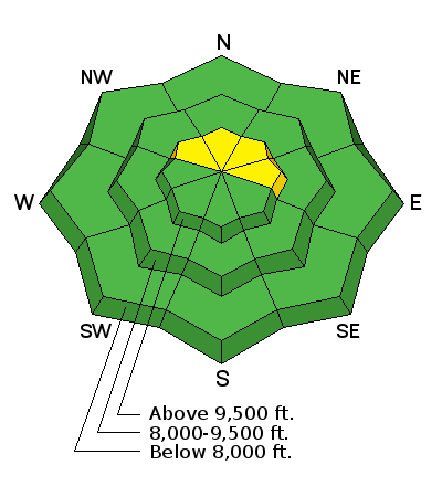
bottom line The majority of the terrain along the Skyline has a LOW avalanche danger. There is still a "spotty" chance that a person could trigger a pocket in the higher northwest through east facing slopes steeper than 35 degrees. There is a scattered "MODERATE" avalanche danger in this terrain. The reality is that you are safe from avalanches in most places. Hitting rocks and stumps in the shallow snowpack is actually a bigger concern right now.
|
 |
current conditions Wow, what an unusual winter. Snow depths and conditions are pretty sad. A few periods of strong wind during the week really did a number on the shallow snowpack. Some areas have been stripped down to the dirt while others have stiff sastrugi. (wave like formations in the snow caused from wind)
If you sniff around you can still find some dense powder that is nice for turning. Temperatures have remained very mild for most of the week. Access from lower elevation trailheads is becoming difficult due to snow melting off the roads. |
| type | aspect/elevation | characteristics |
|---|

|
|
LIKELIHOOD
 LIKELY
UNLIKELY
SIZE
 LARGE
SMALL
TREND
 INCREASING DANGER
SAME
DECREASING DANGER
|
|
description
The snowpack continues to relax over time. There is weak snow all over the Skyline although currently it is pretty stable. This will certainly change if we ever get a significant snow storm. The current weak snow will produce avalanches if we ever really load it up with new snow. If you really try hard, you may get a pocket to release in the upper elevation north through east facing terrain although chances for this diminish each day that goes by with no new snow added on top of the weak snowpack. That said, it is hard to trust buried weak sugary faceted snow. It will trick you when you think there is no chance for triggering an avalanche. This is why I continue to mention a MODERATE avalanche danger still exists. |
 |
weather A minor weather disturbance will move through today brining mostly cloudy skies, gusty ridge top northwest wind and perhaps some very light snow. Ridge top high temperatures will get into the mid 30s. Sunday looks a little nicer with clearer skies and lighter wind. A small storm is shaping up for Tuesday which might bring us a few inches of snow. The big picture is the ridge of high pressure off the west coast continues to mess with our winter storms and there is no significant storm on the horizon as of now. |
| general announcements Support the Utah Avalanche Center through your everyday shopping. DETAILS HERE We will publish full detailed advisories Saturday and Sunday mornings by 7am. We will also be publishing basic avalanche danger ratings & info during the week. If you are getting out into the mountains, we love to hear from you! You can SUBMIT OBSERVATIONS ONLINE or EMAIL US If you would like to have avalanche advisories emailed to you, SIGN UP HERE We can provide basic avalanche awareness presentations for your school, group or club. To enquire, CLICK HERE |


