25th Annual Black Diamond Fall Fundraising Party
Thursday, September 13; 6:00-10:00 PM; Black Diamond Parking Lot
25th Annual Black Diamond Fall Fundraising Party
Thursday, September 13; 6:00-10:00 PM; Black Diamond Parking Lot
| Advisory: Skyline Area Mountains | Issued by Brett Kobernik for Friday - January 26, 2018 - 6:38am |
|---|

|
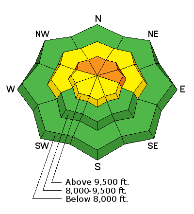
bottom line The avalanche danger is CONSIDERABLE on steep slopes above about 9500' that face northwest, north and east. Human triggered avalanches are likely in this terrain today. Strong winds that drifted snow on Thursday along with new snow overnight has increased the avalanche danger. Buried weak snow near the ground is likely to collapse and cause avalanches.
|
 |
special announcement We are offering a Motorized Backcountry 101 avalanche class on February 10th. DETAILS HERE |
 |
current conditions The Skyline got a quick shot of snow last night with new snow amounts in the 3 to 7 inch range. It looks like the central portion of the Skyline from Pleasant Creek down through about Manti Canyon did the best with 5 to 7 inches. Fairview Canyon is in the 3 inch range. The wind blew vary strong from the southwest Thursday afternoon. This transported snow into fresh drifts which are now hidden by the new snow. The wind continues to slow this morning. Mountain temperatures are in the low teens currently. |
 |
weather
|
| general announcements Support the Utah Avalanche Center through your everyday shopping. DETAILS HERE We will publish full detailed advisories Saturday and Sunday mornings by 7am. We will also be publishing basic avalanche danger ratings & info during the week. If you are getting out into the mountains, we love to hear from you! You can SUBMIT OBSERVATIONS ONLINE or EMAIL US If you would like to have avalanche advisories emailed to you, SIGN UP HERE We can provide basic avalanche awareness presentations for your school, group or club. To enquire, CLICK HERE |


