25th Annual Black Diamond Fall Fundraising Party
Thursday, September 13; 6:00-10:00 PM; Black Diamond Parking Lot
25th Annual Black Diamond Fall Fundraising Party
Thursday, September 13; 6:00-10:00 PM; Black Diamond Parking Lot
| Advisory: Skyline Area Mountains | Issued by Brett Kobernik for Thursday - December 21, 2017 - 7:38am |
|---|


|
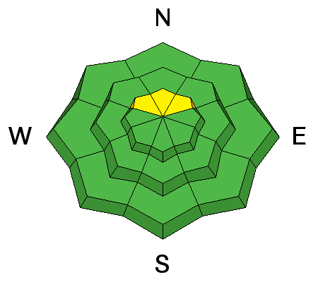
bottom line Avalanche conditions are generally safe right now EXCEPT for the highest due north facing slopes where there is a MODERATE avalanche danger. Human triggered slab avalanches are possible on some of these slopes. If you avoid steep north facing slopes above 9800', the avalanche danger is generally LOW.
|
 |
current conditions Finally we see a snow storm! A strong cold front moved through Wednesday evening and stacked up 4" of snow fairly quickly and more falling overnight bringing the totals to 8 to 10" this morning. The Farnsworth weather station in the Fish Lake region has recorded 24" of snow! Ridgetop temperatures are 10˚F this morning. Wind is blowing in the moderate range from the west northwest across the upper ridges. |
| type | aspect/elevation | characteristics |
|---|

|
|
LIKELIHOOD
 LIKELY
UNLIKELY
SIZE
 LARGE
SMALL
TREND
 INCREASING DANGER
SAME
DECREASING DANGER
|
|
description
The only real avalanche concern for today would be in the highest steep north facing slopes. Old snow from earlier this season has been sitting around on these slopes and has become very weak. It's unclear if the current storm will add enough snow on top of the old weak snow to create an unstable situation. Also, the old weak snow is spotty in distribution, some slopes have enough to be a problem, some don't. The most likely spots to find trouble would be on steep north facing slopes above about 9800' in elevation from about Staker Canyon south through at least Ephraim Canyon. In general, even with the new snow, travel is still difficult and very limited. However, if you are getting out to check out the new snow, approach those high north slopes with caution. |
 |
weather We'll see a little more snow this morning into this afternoon before the storm moves out. We might see another 3 to 5" if we're lucky. High temps should get into the low teens. Northwest wind will be in the moderate speed range across the ridges. We should see some sun on Friday with temperatures rebounding a bit more. It looks like partly cloudy skies through the weekend with ridge top temperatures in the 20s. A "brush-by" storm rolls to the northeast of us on Christmas which won't do much for snow in our region. The next decent chance for snow looks like Weds/Thurs of next week. |


