25th Annual Black Diamond Fall Fundraising Party
Thursday, September 13; 6:00-10:00 PM; Black Diamond Parking Lot
25th Annual Black Diamond Fall Fundraising Party
Thursday, September 13; 6:00-10:00 PM; Black Diamond Parking Lot
| Advisory: Skyline Area Mountains | Issued by Brett Kobernik for Saturday - April 1, 2017 - 6:45am |
|---|

|
bottom line The avalanche danger is generally LOW this morning. The danger may increase slightly during the day as the new snow gets heated up for the first time.
|
 |
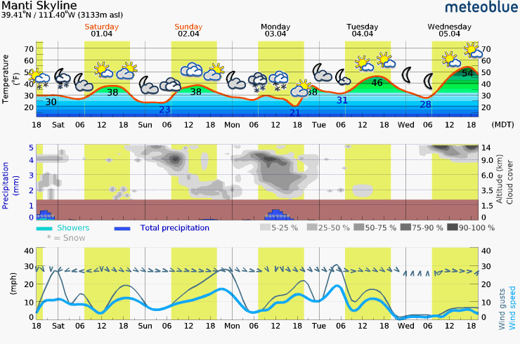
current conditions A few more inches of snow trickled in late Friday afternoon and Friday night. However, due to settlement, total storm depths didn't increase a whole lot. This morning you'll find about 5 inches new snow above the old snow surface from Thursday. It'll be dense but should provide great riding conditions. Keep in mind that it will become warm and wet quickly as it always does in the spring when the sun pokes out. Wind has been from the northeast in the moderate speed range along the higher elevations and seems to be slowing at most stations. Temperatures were in the mid 20s to around 30˚F along the ridges overnight. |
| type | aspect/elevation | characteristics |
|---|

|
|
LIKELIHOOD
 LIKELY
UNLIKELY
SIZE
 LARGE
SMALL
TREND
 INCREASING DANGER
SAME
DECREASING DANGER
|
|
description
Things are fairly safe out there unless you're really pushing it into the more radical steep terrain. The main concern today will be how the new snow responds to the sun and daytime heating. It doesn't look like an overly warm day so I'm not anticipating much wet avalanche activity. Things to keep in mind during the spring:
|
 |
weather The storm is clearing out and we should see some sun in the mountains today. Ridgetop temperatures will get into the mid 30s. Wind will be northerly in the light to moderate speed category. We'll have partly cloudy skies on Sunday with slightly similar temperatures. Another storm will move through on Monday. As of now I would say it looks like about a 2 to 5" snow event.
|
| general announcements We will publish full detailed advisories Saturday and Sunday mornings by 7am. We will also be publishing basic avalanche danger ratings & info during the week. If you are getting out into the mountains, we love to hear from you! You can SUBMIT OBSERVATIONS ONLINE or EMAIL US If you would like to have avalanche advisories emailed to you, SIGN UP HERE We can provide basic avalanche awareness presentations for your school, group or club. To enquire, CLICK HERE |