25th Annual Black Diamond Fall Fundraising Party
Thursday, September 13; 6:00-10:00 PM; Black Diamond Parking Lot
25th Annual Black Diamond Fall Fundraising Party
Thursday, September 13; 6:00-10:00 PM; Black Diamond Parking Lot
| Advisory: Skyline Area Mountains | Issued by Brett Kobernik for Friday - March 24, 2017 - 6:55am |
|---|


|
bottom line The avalanche danger is MODERATE today for human triggered new snow avalanches. Natural wet avalanches are also possible today. Move off and stay out from underneath steep slopes that are becoming really wet.
|
 |
current conditions Well that was a nice little storm! The southern end of the Skyline from Ephraim Canyon south faired the best with about a foot total of new snow. The Fairview Canyon area picked up about 6 inches. The rain-snow line dropped down to around 7000 feet on Thursday. The wind is from the northwest and has slowed. It looks just slightly breezy along the higher elevations. Skies are clear and temperatures are in the mid 20s. I did not note any significant weakness within the new snow and it wasn't sensitive to skis or snowmachines. However, visibility was poor and I wasn't able to prowl around the higher terrain where the wind was drifting snow. I would anticipate some deeper drifts along the higher ridges that may be sensitive yet this morning. |
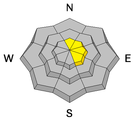
| type | aspect/elevation | characteristics |
|---|

|

|
LIKELIHOOD
 LIKELY
UNLIKELY
SIZE
 LARGE
SMALL
TREND
 INCREASING DANGER
SAME
DECREASING DANGER
|
|
description
You're main concern is the new snow becoming unstable from daytime heating and direct sun. East faces will heat up first, then south then west later in the day. Watch for rollerballs and pinwheeling. Once the snow becomes wet enough, it will be possible to initiate wet loose avalanches that could gain enough momentum on larger slopes to be dangerous. |
| type | aspect/elevation | characteristics |
|---|

|
|
LIKELIHOOD
 LIKELY
UNLIKELY
SIZE
 LARGE
SMALL
TREND
 INCREASING DANGER
SAME
DECREASING DANGER
|
|
description
The recent wind slabs that formed yesterday may still be a little sensitive today. Heating on the east facing slopes will make these unstable. Avoid cornices and fresh drifts along the upper ridgelines. |
 |
weather We'll see sunny skies today with ridgetop temperatures getting into the mid to upper 30s. Wind will remain generally light from the northwest. Another storm moves through on Saturday potentially giving us a few more inches of snow then another fairly nice day on Sunday. More storms are expected next week.
|
| general announcements We will publish full detailed advisories Saturday and Sunday mornings by 7am. We will also be publishing basic avalanche danger ratings & info during the week. If you are getting out into the mountains, we love to hear from you! You can SUBMIT OBSERVATIONS ONLINE or EMAIL US If you would like to have avalanche advisories emailed to you, SIGN UP HERE We can provide basic avalanche awareness presentations for your school, group or club. To enquire, CLICK HERE |


