25th Annual Black Diamond Fall Fundraising Party
Thursday, September 13; 6:00-10:00 PM; Black Diamond Parking Lot
25th Annual Black Diamond Fall Fundraising Party
Thursday, September 13; 6:00-10:00 PM; Black Diamond Parking Lot
| Advisory: Skyline Area Mountains | Issued by Brett Kobernik for Wednesday - March 15, 2017 - 7:05am |
|---|


|
bottom line The avalanche danger is increasing as temperatures continue to stay warm. There is a MODERATE danger of triggering a wet avalanche today. Natural wet avalanches are possible. Cornices may start to break off naturally. Avoid being below large steep slopes that have become really wet and sloppy.
|
 |
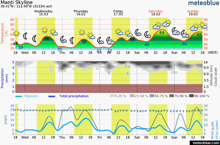
current conditions Last night was the second consecutive night with low temperatures above freezing in the mountains. Most stations were in the upper 30s. |
| type | aspect/elevation | characteristics |
|---|

|

|
LIKELIHOOD
 LIKELY
UNLIKELY
SIZE
 LARGE
SMALL
TREND
 INCREASING DANGER
SAME
DECREASING DANGER
|
|
description
The danger for wet avalanches is increasing with no solid overnight refreeze of the snowpack. It is difficult to say if we'll see any significant avalanche activity because timing of wet avalanches is hard to predict. Two to three nights with no refreeze is generally needed before any significant activity occurs.
|
 |
weather
|
| general announcements We will publish full detailed advisories Saturday and Sunday mornings by 7am. We will also be publishing basic avalanche danger ratings & info during the week. If you are getting out into the mountains, we love to hear from you! You can SUBMIT OBSERVATIONS ONLINE or EMAIL US If you would like to have avalanche advisories emailed to you, SIGN UP HERE We can provide basic avalanche awareness presentations for your school, group or club. To enquire, CLICK HERE |