25th Annual Black Diamond Fall Fundraising Party
Thursday, September 13; 6:00-10:00 PM; Black Diamond Parking Lot
25th Annual Black Diamond Fall Fundraising Party
Thursday, September 13; 6:00-10:00 PM; Black Diamond Parking Lot
| Advisory: Skyline Area Mountains | Issued by Brett Kobernik for Saturday - January 14, 2017 - 6:59am |
|---|


|
bottom line Most of the terrain has a MODERATE avalanche danger today. Human triggered avalanches are possible. The danger may rise to CONSIDERABLE on sunny slopes with daytime heating. Cornices and drifts along the upper ridges may still be sensitive.
|
 |
special announcement State Road 31 is closed at the top of Fairview Canyon at the junction with State Road 264. Huntington Canyon also remains closed. Parking along the roads is going to be an issue this weekend. You will not be able to access the parking lots along the Skyline Summit/Big Drift area or Miller Flat due to snow removal that still needs to be completed. The closures will most likely last through Sunday. |
 |
current conditions The series of storms has finally moved out of our area. We received up to 3' of snow containing 5" of water since Sunday. The west southwest wind was quite strong during the week but slowed on Thursday and is currently light. Temperatures are around 20F. The riding conditions are good with soft new snow everywhere although it is not deep powder. A lot of the snow that fell this week was quite high density. Temperatures on Friday reached the upper 20s to low 30s which created significant settlement of the snow already. Overall, the snowpack is looking good and becoming more stable. That being said, it is wise to not just go hit the big terrain right out of the gate this morning. |
 |
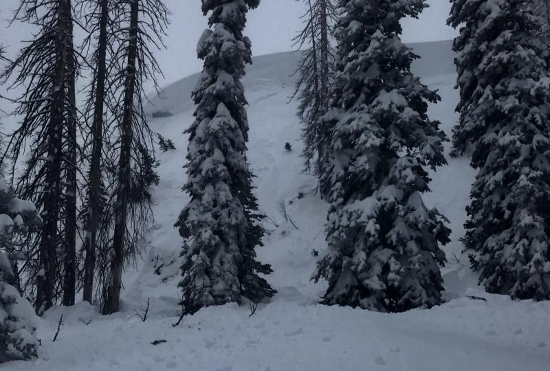
recent activity Explosive testing in Huntington Canyon near the Camp Chutes produced no significant results on Friday. This is encouraging as this terrain is somewhat similar to other areas of the higher terrain along the Skyline where the snowpack is fairly deep, consolidated and becoming more stable. Lower Huntington Canyon is a different story with a much shallower and weaker snowpack. This is where trouble is still suspected. There was one avalanche triggered on Friday between the Fairview Lakes area and the Big Drift. it was about 3' deep. Judging by nearby sled tracks, it looks like it was triggered from a distance. This is near an area where some buried surface hoar caused some avalanche activity recently.
Photo: Cade Beck |
| type | aspect/elevation | characteristics |
|---|

|
|
LIKELIHOOD
 LIKELY
UNLIKELY
SIZE
 LARGE
SMALL
TREND
 INCREASING DANGER
SAME
DECREASING DANGER
|
|
description
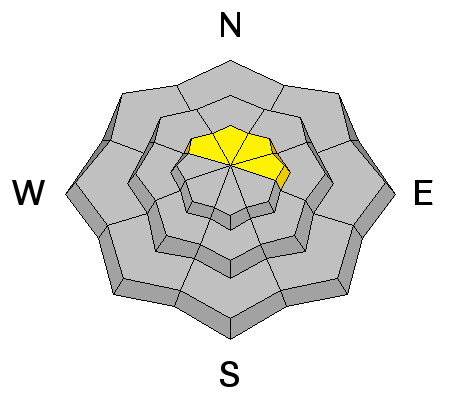
There are a number of things to keep in mind today. The first is all the recently formed drifts near the ridges may still be sensitive. These are stabilizing rapidly but I will be testing small slopes with no consequences to see how sensitive things are before getting onto any bigger slopes. You can hit numerous smaller drifts to see if they crack to get an idea of how sensitive the drifts are. |
| type | aspect/elevation | characteristics |
|---|

|

|
LIKELIHOOD
 LIKELY
UNLIKELY
SIZE
 LARGE
SMALL
TREND
 INCREASING DANGER
SAME
DECREASING DANGER
|
|
description
The next thing to consider is how damp the snow gets in the direct sun today. Slopes that face the sun may become unstable during the day today as things warm up. Look for "rollerballs" or "pinwheels" forming on the surface. This is a sure sign that the snow is becoming wet and you should avoid being on or under steep slopes at that time. Today's heat may trigger some slab avalanches in the lower terrain below 8500. |
| type | aspect/elevation | characteristics |
|---|

|
|
LIKELIHOOD
 LIKELY
UNLIKELY
SIZE
LARGE
SMALL
TREND
INCREASING DANGER
SAME
DECREASING DANGER
|
|
description
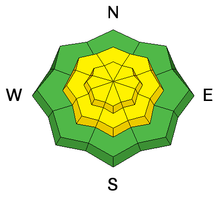
Lastly, there are areas scattered around where a person could trigger an avalanche breaking into a persistent weak layer that formed during the Christmas Week. We have seen some activity from buried surface hoar around the Fairview Lakes-Electric Lake-Huntington Reservoir area. These "booby traps" will most likely be found in steep, northerly protected areas. Being in trees doesn't make things safe. |
 |
weather We'll see quite a bit of sun today with ridgetop high temperatures in the upper 20s and low 30s. Wind will be calm to light in speed. We'll see more clouds on Sunday and slightly cooler temperatures. High pressure with nice weather will continue into early next week. |
| general announcements We will publish full detailed advisories Saturday and Sunday mornings by 7am. We will also be publishing basic avalanche danger ratings & info during the week. If you are getting out into the mountains, we love to hear from you! You can SUBMIT OBSERVATIONS ONLINE or EMAIL US If you would like to have avalanche advisories emailed to you, SIGN UP HERE We can provide basic avalanche awareness presentations for your school, group or club. To enquire, CLICK HERE |