25th Annual Black Diamond Fall Fundraising Party
Thursday, September 13; 6:00-10:00 PM; Black Diamond Parking Lot
25th Annual Black Diamond Fall Fundraising Party
Thursday, September 13; 6:00-10:00 PM; Black Diamond Parking Lot
| Advisory: Skyline Area Mountains | Issued by Brett Kobernik for Thursday - January 12, 2017 - 6:56am |
|---|

|
bottom line The avalanche danger is HIGH today. Backcountry travel is not recommended. Natural avalanches are likely. Stay off of and out from under any steep snow covered slope.
|
 |
avalanche warning An AVALANCHE WARNING has been issued through the National Weather Service. Recent snow and wind combined with additional snow today has created a HIGH avalanche danger. |
 |
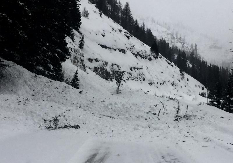
special announcement HUNTINGTON CANYON IS CURRENTLY CLOSED AND WILL NOT REOPEN UNTIL FRIDAY DUE TO AVALANCHE DANGER AND DEBRIS ON THE ROAD.
I'll be doing an avalanche presentation at Big Pine Sports Thursday, January 12th at 6:30pm. I'll be covering a bunch of topics including "Persistent Weak Layer Formation" which is about how these weak layers form and how to manage them once they're buried. There will be food and drinks and some discounts on gear. Come join us and get a little more avalanche education! DETAILS |
 |
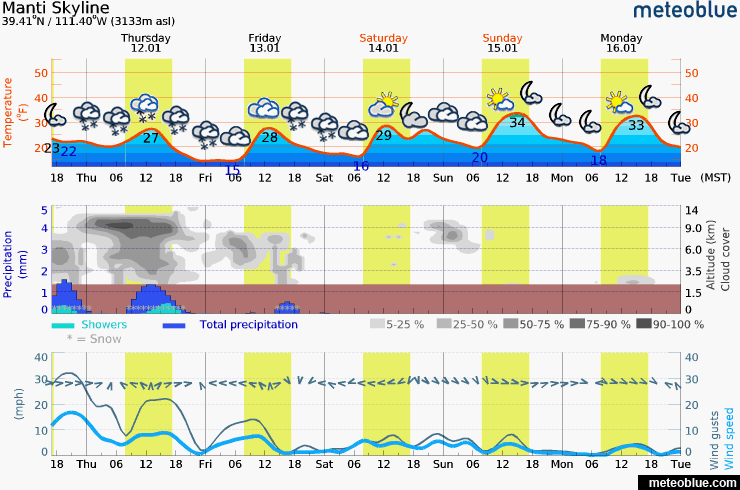
current conditions We've received 4 to 8 inches of snow in the last 24 hours. That brings totals over the last 7 days up to around 20 to 30 inches. Water content is in the 2 to 3.5 inch range. It looks to me like the northern end of the Skyline has faired better with snow than the southern end so far. The southwest wind peaked at almost 80mph along the highest ridges mid day on Wednesday and has slowed dramatically since. Temperatures have been in the low to mid 20s. |
 |
recent activity More natural avalanches released early Wednesday morning in Huntington Canyon again crossing the road and leaving large piles of debris.
|
 |
weather One more storm wave will move through today in a southerly flow. It looks like it may have a little southeast component to it which could favor some canyons on the east side of the Skyline such as Huntington Canyon due to "Orographic Lift" or "upslope snow enhancement". We could see over a foot of new snow today and into tonight with over an inch of water with it. If this happens, this will be the big contributor to today's HIGH avalanche danger. One good thing is that the wind won't be as strong as it's been but the additional water weight from the new snow could tip the scales alone. Snowfall may continue into Friday but should taper off then. It looks like nice weather for the upcoming weekend.
|
| general announcements We will publish full detailed advisories Saturday and Sunday mornings by 7am. We will also be publishing basic avalanche danger ratings & info during the week. If you are getting out into the mountains, we love to hear from you! You can SUBMIT OBSERVATIONS ONLINE or EMAIL US If you would like to have avalanche advisories emailed to you, SIGN UP HERE We can provide basic avalanche awareness presentations for your school, group or club. To enquire, CLICK HERE |