25th Annual Black Diamond Fall Fundraising Party
Thursday, September 13; 6:00-10:00 PM; Black Diamond Parking Lot
25th Annual Black Diamond Fall Fundraising Party
Thursday, September 13; 6:00-10:00 PM; Black Diamond Parking Lot
| Advisory: Skyline Area Mountains | Issued by Brett Kobernik for Friday - December 23, 2016 - 7:05am |
|---|

|
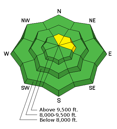
bottom line The avalanche danger remains LOW in the majority of the terrain along the Manti-Skyline. There is an isolated chance that someone might trigger a small wind drift along the highest and steepest terrain. ANTICIPATE A RISING AVALANCHE DANGER ON SATURDAY DURING THE STORM.
|
 |
current conditions About 3 inches of new snow fell in the last 24 hours. It was pretty even in distribution from Temperatures are around 20 in the higher locations and wind speeds have bumped up slightly into a more normal speed from the west. |
 |
weather We have a little clearing right now in the high country. More clouds will move in today as the next significant storm approaches. We'll start to see snow later today but the majority will fall on Saturday into Sunday. We may see a foot or more of accumulation. Temperatures start out warm during the storm and cool down into the single digits on Sunday. This should produce another "right side up" storm with higher density snow to begin and lower density snow as the storm progresses.
|
| general announcements We will publish full detailed advisories Saturday and Sunday mornings by 7am. We will also be publishing basic avalanche danger ratings & info during the week. If you are getting out into the mountains, we love to hear from you! You can SUBMIT OBSERVATIONS ONLINE or EMAIL US If you would like to have avalanche advisories emailed to you, SIGN UP HERE We can provide basic avalanche awareness presentations for your school, group or club. To enquire, CLICK HERE |


 the bottom of the Sanpete Valley to the higher terrain. This is because there was very little wind to produce