25th Annual Black Diamond Fall Fundraising Party
Thursday, September 13; 6:00-10:00 PM; Black Diamond Parking Lot
25th Annual Black Diamond Fall Fundraising Party
Thursday, September 13; 6:00-10:00 PM; Black Diamond Parking Lot
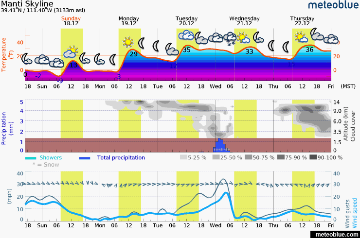
| Advisory: Skyline Area Mountains | Issued by Brett Kobernik for Tuesday - December 20, 2016 - 7:04am |
|---|

|
bottom line The majority of the terrain out there has a LOW avalanche danger. There is a MODERATE danger in isolated places along the higher ridges on very steep slopes where a person could trigger a drift that has formed recently.
|
 |
current conditions Sun and warmer temperatures have formed a crust on the more southerly facing slopes. There was a little southewest wind transporting snow along the upper ridges on Monday. A few new small drifts may have formed although I did not see anything too significant. The snowpack is mostly stable right now. The deeper base layers are consolidated and are bonding. The newest snow does not have any weakness either. A person might be able to trigger a fresh wind drift in isolated places along the highest north through east facing steep terrain. |
 |
weather We have a nice day in store with mostly sunny skies and ridgetop temperatures in the upper 20s. Southwest wind will be mostly light in speed. A small storm moves through tonight that might produce a few flurries but no accumulation is expected. A bigger storm is shaping up for the weekend although confidence is low as to just how things will shake out. European and U.S. weather models are not in agreement at this time.
|
| general announcements We will publish full detailed advisories Saturday and Sunday mornings by 7am. We will also be publishing basic avalanche danger ratings & info during the week. If you are getting out into the mountains, we love to hear from you! You can SUBMIT OBSERVATIONS ONLINE or EMAIL US If you would like to have avalanche advisories emailed to you, SIGN UP HERE We can provide basic avalanche awareness presentations for your school, group or club. To enquire, CLICK HERE |