25th Annual Black Diamond Fall Fundraising Party
Thursday, September 13; 6:00-10:00 PM; Black Diamond Parking Lot
25th Annual Black Diamond Fall Fundraising Party
Thursday, September 13; 6:00-10:00 PM; Black Diamond Parking Lot
| Advisory: Skyline Area Mountains | Issued by Brett Kobernik for Wednesday - December 14, 2016 - 6:53am |
|---|

|
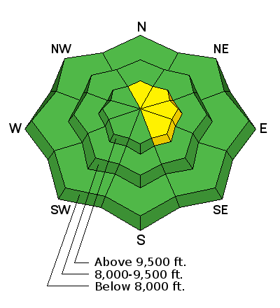
bottom line The majority of the terrain has a LOW avalanche danger. A MODERATE avalanche danger exists along the higher, steepest, most exposed ridges and peaks where a person could trigger a fresh wind drift. Watch for textured or "pillowy" looking snow and avoid it if it is on a steep slope.
|
 |
special announcement Please join us at Big Pine Sports for an avalanche presentation on Thursday, Dec 15th at 6:30pm. I will be talking about the current conditions and sharing tips on how to stay out of avalanches. I'll cover anything else avalanche related the audience is interested in.
|
 |
current conditions A trace to an inch of new snow fell over the last couple hours. The wind is still breezy along the higher terrain. The snowpack currently looks good and is mostly stable. For more details on the current snowpack, check out my findings from yesterday HERE |
| type | aspect/elevation | characteristics |
|---|

|
|
LIKELIHOOD
 LIKELY
UNLIKELY
SIZE
 LARGE
SMALL
TREND
 INCREASING DANGER
SAME
DECREASING DANGER
|
|
description
Triggering a fresh wind slab on the more east facing steep terrain is the biggest avalanche concern out there right now. |
 |
weather
|
| general announcements We will publish full detailed advisories Saturday and Sunday mornings by 7am. We will also be publishing basic avalanche danger ratings & info during the week. If you are getting out into the mountains, we love to hear from you! You can SUBMIT OBSERVATIONS ONLINE or EMAIL US If you would like to have avalanche advisories emailed to you, SIGN UP HERE We can provide basic avalanche awareness presentations for your school, group or club. To enquire, CLICK HERE |


