25th Annual Black Diamond Fall Fundraising Party
Thursday, September 13; 6:00-10:00 PM; Black Diamond Parking Lot
25th Annual Black Diamond Fall Fundraising Party
Thursday, September 13; 6:00-10:00 PM; Black Diamond Parking Lot
| Advisory: Skyline Area Mountains | Issued by Brett Kobernik for Saturday - December 10, 2016 - 6:50am |
|---|


|
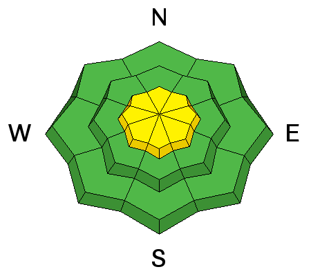
bottom line The avalanche danger is MODERATE along the higher ridgelines where the wind has been drifting snow. Avoid fresh cornices as well as any steep slopes where the wind has been depositing snow recently. Out of the wind effected terrain, the avalanche danger is LOW.
|
 |
special announcement Please join us at Big Pine Sports for an avalanche presentation on Thursday, Dec 15th at 6:30pm. I will be talking about the current conditions and sharing tips on how to stay out of avalanches. I'll cover anything else avalanche related the audience is interested in.
|
 |
current conditions Warm temperatures on Friday headline the avalanche news. Many stations in the 9500' range hit the mid 30s F and are still in that range this morning! The snow surface was at least somewhat damp up to that elevation and completely damp from the snow surface to the ground below around 8600' The wind continued to blow across the higher ridgelines but was not too annoying if you stayed off the exposed terrain. It is still breezy along the higher terrain this morning. If you want more detail about the current snowpack and avalanche conditions, check out these observations from this week:
|
| type | aspect/elevation | characteristics |
|---|

|
|
LIKELIHOOD
 LIKELY
UNLIKELY
SIZE
 LARGE
SMALL
TREND
 INCREASING DANGER
SAME
DECREASING DANGER
|
|
description
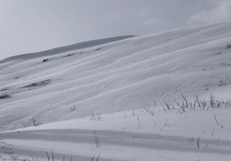
Recent wind deposited snow remains the biggest concern for backcountry travelers. This will mainly only be found above 9500' and on slopes over 35 degrees in steepness. The more east facing terrain is more likely to have these drifts that could release but you may encounter pockets on slopes that face various directions. Look for rippled, textured or wavy looking patterns on the snow surface and avoid those areas if they are on steep slopes.
textured and rippled looking snow is formed from the wind |
 |
weather It's going to be another warm windy day today with snow moving in mid day. Temperatures will remain very mild but will start to drop with the next portion of this storm. Current weather models are suggesting about 1" of water with this next impulse which should translate to 8 or 10 inches of snow by the time it's done Sunday morning. We should see some clearing mid day on Sunday and continued breezy ridgetop wind. We remain in this mild temperature breezy westerly flow through next week with the next chance for snow Tuesday night. |
| general announcements We will publish full detailed advisories Saturday and Sunday mornings by 7am. We will also be publishing basic avalanche danger ratings & info during the week. If you are getting out into the mountains, we love to hear from you! You can SUBMIT OBSERVATIONS ONLINE or EMAIL US If you would like to have avalanche advisories emailed to you, SIGN UP HERE We can provide basic avalanche awareness presentations for your school, group or club. To enquire, CLICK HERE |