25th Annual Black Diamond Fall Fundraising Party
Thursday, September 13; 6:00-10:00 PM; Black Diamond Parking Lot
25th Annual Black Diamond Fall Fundraising Party
Thursday, September 13; 6:00-10:00 PM; Black Diamond Parking Lot
| Advisory: Skyline Area Mountains | Issued by Brett Kobernik for Friday - December 2, 2016 - 7:13am |
|---|

|
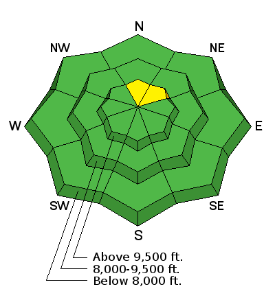
bottom line Most of the terrain has a LOW avalanche danger. A MODERATE danger exists on the highest, steepest north through northeast terrain where a lingering wind drift could release.
|
 |
current conditions We recieved 2 to 3 inches of snow overnight. The wind has been light and variable in direction. Temperatures are in the single digits. |
 |
recent activity No significant recent avalanche activity has been observed or reported. |
 |
weather STATE WEATHER SYNOPSIS...A cold upper trough will remain overhead today. High pressure will move over the region tonight into Sunday. A colder upper trough will slowly cross the area through the first half of next week. |
| general announcements We will publish full detailed advisories Saturday and Sunday mornings by 7am. We will also be publishing basic avalanche danger ratings & info during the week. If you are getting out into the mountains, we love to hear from you! You can SUBMIT OBSERVATIONS ONLINE or EMAIL US If you would like to have avalanche advisories emailed to you, SIGN UP HERE We can provide basic avalanche awareness presentations for your school, group or club. To enquire, CLICK HERE |


