| Please join us at the 23rd annual Black Diamond Fall Fundraiser Party Thursday Sept 15. Tickets are on sale now here, at the Black Diamond store & at REI. Special bonus raffle for online ticket purchasers! |
| Please join us at the 23rd annual Black Diamond Fall Fundraiser Party Thursday Sept 15. Tickets are on sale now here, at the Black Diamond store & at REI. Special bonus raffle for online ticket purchasers! |
| Advisory: Skyline Area Mountains | Issued by Brett Kobernik for Saturday - February 13, 2016 - 10:38pm |
|---|

|
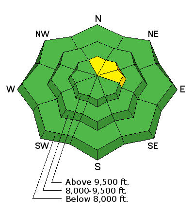
bottom line The majority of the terrain out there has a LOW avalanche danger. However, a MODERATE avalanche danger still exists on steep north through east upper elevation slopes that have already slid this season. It is difficult to judge whether a slope has already slid just by looking at it right now.
|
 |
current conditions Temperatures finally cooled off last night dipping into the mid 20s along the higher terrain. Wind speeds picked up into the moderate speed category and are still slightly gusty this morning from the west northwest. Sunny slopes have a melt-freeze crust on them. Shaded slopes hold dense powder. This powder is actually small grained faceted snow but it doesn't appear loose enough at this time to act as a weak layer once it gets buried. |
 |
recent activity There were a couple of snowmobile triggered slides that most likely released early Saturday morning. The first was a significant slide in Lake Canyon near Miller Flat along SR31. It broke on weak facets near the ground and was 2 to 3 feet deep and around 500 feet wide. This is the third time this path has avalanched this season. DETAILS HERE
The other avalanche was in the Gooseberry area south of I-70. It also broke to the ground. It's not clear at this time if this path had avalanched earlier this season but we should be able to find out.
|
| type | aspect/elevation | characteristics |
|---|

|
|
LIKELIHOOD
 LIKELY
UNLIKELY
SIZE
 LARGE
SMALL
TREND
 INCREASING DANGER
SAME
DECREASING DANGER
|
|
description
While triggering an avalanche that breaks to the ground is becoming less likely as time goes on, the two recent slides do demonstrate that the snowpack is not 100% stable. The most likely spots to trigger something is on avalanche paths that have already avalanched this year and are approaching 40 degrees in steepness which face north, northeast and east. I know a number of slopes that avalanched in December and are reloaded now just waiting for a trigger just like the avalanche in Lake Canyon. |
 |
weather We'll see partly to mostly cloudy skies today with increasing west northwest wind. High temperatures won't be as warm as they've been but will still be in the mid 30s. A "brush-by" storm will clip northern Utah later today and tonight with some light snowfall. We'll only see a trace to a couple of inches of snow by Monday. High pressure returns with warmer weather again Tuesday and Wednesday. Models are still portraying a storm on Thursday. The GFS model looks a little wetter while the EC model doesn't look as good. |
| general announcements We will publish full detailed advisories Saturday and Sunday mornings by 7am. We will also be publishing basic avalanche danger ratings & info during the week. If you are getting out into the mountains, we love to hear from you! You can SUBMIT OBSERVATIONS ONLINE or EMAIL US If you would like to have avalanche advisories emailed to you, SIGN UP HERE We can provide basic avalanche awareness presentations for your school, group or club. To enquire, CLICK HERE |


