| Please join us at the 23rd annual Black Diamond Fall Fundraiser Party Thursday Sept 15. Tickets are on sale now here, at the Black Diamond store & at REI. Special bonus raffle for online ticket purchasers! |
| Please join us at the 23rd annual Black Diamond Fall Fundraiser Party Thursday Sept 15. Tickets are on sale now here, at the Black Diamond store & at REI. Special bonus raffle for online ticket purchasers! |
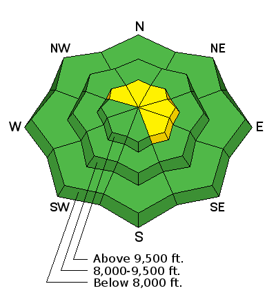
| Advisory: Skyline Area Mountains | Issued by Brett Kobernik for Sunday - January 10, 2016 - 7:02am |
|---|

|
bottom line The majority of the terrain has a LOW avalanche danger today. In the upper elevation terrain there is a MODERATE avalanche danger. Be mindful of fresh drifts of snow that may have formed overnight on the more east facing slopes. It is unlikely at this point but there is still a chance a person could trigger an avalanche that breaks into old weak snow near the ground. Upper elevation west, north and east facing VERY steep slopes (approching 40 degrees) in shallow snowpack locations would be places you might find trouble.
|
 |
special announcement Be sure to check Skyline snow and avalanche info on Instagram @skyline_avalanche |
 |
current conditions It's a bit cool out this morning with ridgetop temperatures in the low teens. There was a slight bump in northwest wind speeds overnight and they look like they are slowing again. This was probably enough to transport some of the nice powder and form some new drifts. In most of the mid and upper elevations, there seems to be a fairly even blanket of about 6 inches of snow that fell during the week. Riding conditions remain very good. |
| type | aspect/elevation | characteristics |
|---|

|

|
LIKELIHOOD
 LIKELY
UNLIKELY
SIZE
 LARGE
SMALL
TREND
 INCREASING DANGER
SAME
DECREASING DANGER
|
|
description
Fresh wind slabs that formed overnight from the bump in northwest wind speeds should be noted. These won't be very dangerous for snowmobile riders but might knock a person on skis, snowboard or snowshoes over if they get one to crack out. Since the wind was from the northwest, the most likely places to find these will be more on the east facing slopes where the wind will have deposited any snow that got transported. |
| type | aspect/elevation | characteristics |
|---|

|

|
LIKELIHOOD
 LIKELY
UNLIKELY
SIZE
LARGE
SMALL
TREND
 INCREASING DANGER
SAME
DECREASING DANGER
|
|
description
Continue to use caution in the higher terrain if you are planning on getting onto steep slopes. I absolutely hate when we have weak faceted sugary snow within the snowpack. Nothing makes me more nervous. All you can do is wait until it has stabilized. The trick is knowing when it has stabilized. It is not uncommon for us to think that this weak snow has become stable and then someone triggers an avalanche. I do believe that this old weak snow is fairly stable right now but it's still in the back of my mind. Only expose one rider at a time on the steep slopes. Make sure everyone is paying attention and be ready if someone does trigger something. 'Breakovers' with shallow snow are likely spots to trigger something. |
 |
weather A weak storm is going to move central and southern Utah today bringing clouds and possibly light snowfall that won't add up to much accumulation. High ridgetop temperatures will get into the upper teens and northwest winds will be in the light to moderate speed category. We slide into high pressure for Monday, Tuesday and Wednesday with clear skies and warmer temperatures. A splitting storm is shaping up for Thursday that doesn't look too promising for snowfall for our region. |
| general announcements We will publish full detailed advisories Saturday and Sunday mornings by 7am. We will also be publishing basic avalanche danger ratings & info during the week. If you are getting out into the mountains, we love to hear from you! You can SUBMIT OBSERVATIONS ONLINE or EMAIL US If you would like to have avalanche advisories emailed to you, SIGN UP HERE We can provide basic avalanche awareness presentations for your school, group or club. To enquire, CLICK HERE |


