| Please join us at the 23rd annual Black Diamond Fall Fundraiser Party Thursday Sept 15. Tickets are on sale now here, at the Black Diamond store & at REI. Special bonus raffle for online ticket purchasers! |
| Please join us at the 23rd annual Black Diamond Fall Fundraiser Party Thursday Sept 15. Tickets are on sale now here, at the Black Diamond store & at REI. Special bonus raffle for online ticket purchasers! |
| Advisory: Skyline Area Mountains | Issued by Brett Kobernik for Saturday - January 9, 2016 - 6:22am |
|---|


|
bottom line The majority of the terrain out there has a LOW avalanche danger. There is a scattered MODERATE danger still in the upper elevation west, north and east facing slopes approaching 40 degrees in steepness, especially in the more shallow locations. You may still be able to trigger an avalanche that breaks into old weak snow near the ground.
|
 |
special announcement Get the daily avalanche advisory emailed to you! DETAILS HERE |
 |
current conditions The Skyline has picked up about 6" of snow since Monday. It's been just very slowly trickling in. We still have a few flakes falling out of the sky this morning. Northwest wind is light and temperatures have dropped into the mid teens. Riding conditions remain excellent in the mid elevations. The higher terrain is still feeling the effects of the east wind from last week. It's a moonscape of frozen features under the new snow.
|
| type | aspect/elevation | characteristics | ||
|---|---|---|---|---|

|
|
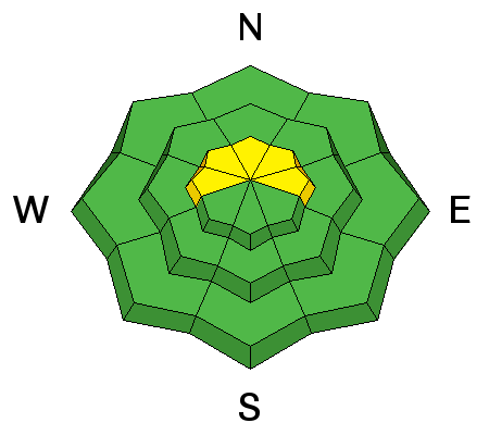
LIKELIHOOD
 LIKELY
UNLIKELY
SIZE
 LARGE
SMALL
TREND
 INCREASING DANGER
SAME
DECREASING DANGER
|
||
|
description
The new snow has not affected the avalanche danger. You may be able to get some loose snow sluffs started in the steepest terrain but I don't think they'll pose much threat. Watch for any increase in wind as this may quickly form fresh sensitive drifts. The warm temperatures during the week sure did help consolidate the snowpack. We have a very strong mid portion of the snowpack. You can still find weak faceted sugary snow near the ground and if you poke around enough in the upper elevation terrain that is approaching 40 degrees in steepness, you might be able to trigger something. This is most pronounced on west, north and east facing slopes especially in areas where the overall snow depth is more shallow. For more detailed thoughts on the snowpack, check out the two observations from Friday:
|
 |
weather The light snowfall should let up as the day goes on and we may see the clouds clear a bit. Northwest wind will be light to moderate in speed. Temperatures will get up to around 20 along the higher terrain today and Sunday. It looks like we'll see a few clouds on Sunday then mostly clear skies into next week. Temperatures warm a bit on Monday. It doesn't look like we'll see any significant storms next week. A minor event might bring a little snow around Thursday or so. The long range models are advertising a more stormy period the following week. |
| general announcements We will publish full detailed advisories Saturday and Sunday mornings by 7am. We will also be publishing basic avalanche danger ratings & info during the week. If you are getting out into the mountains, we love to hear from you! You can SUBMIT OBSERVATIONS ONLINE or EMAIL US If you would like to have avalanche advisories emailed to you, SIGN UP HERE We can provide basic avalanche awareness presentations for your school, group or club. To enquire, CLICK HERE |


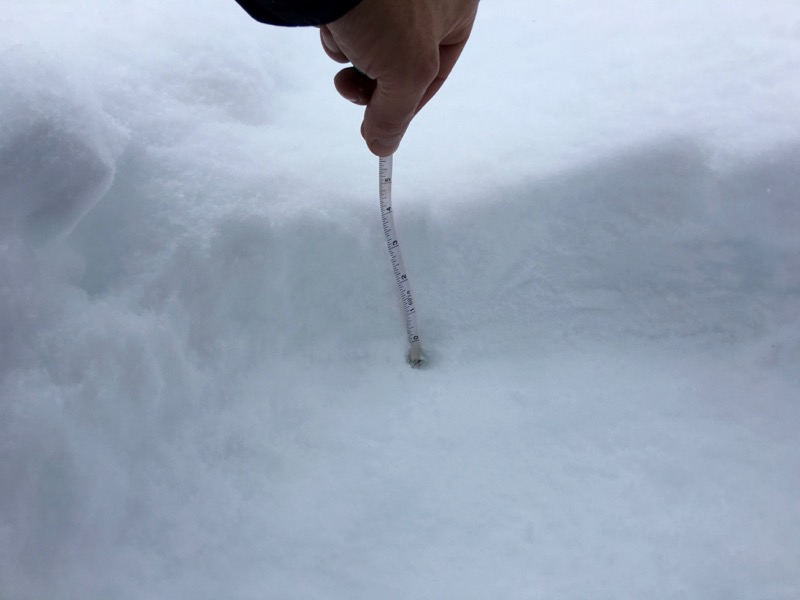 4" new snow on my track from Monday. A few more inches trickled in after I measured this on Friday afternoon.