| Please join us at the 23rd annual Black Diamond Fall Fundraiser Party Thursday Sept 15. Tickets are on sale now here, at the Black Diamond store & at REI. Special bonus raffle for online ticket purchasers! |
| Please join us at the 23rd annual Black Diamond Fall Fundraiser Party Thursday Sept 15. Tickets are on sale now here, at the Black Diamond store & at REI. Special bonus raffle for online ticket purchasers! |
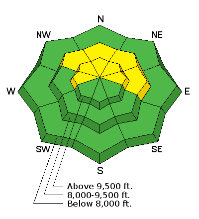
| Advisory: Skyline Area Mountains | Issued by Brett Kobernik for Friday - January 1, 2016 - 6:54am |
|---|

|
bottom line The avalanche danger remains MODERATE on slopes over 35 degrees in steepness that face west, north and east which did not avalanche during last week's natural cycle. It is more pronounced in the higher terrain that faces north through east. Chances of triggering an avalanche are low but if you do, it could be a dangerous situation. Avoid stopping below steep slopes and only put one person on a slope at a time.
|
 |
current conditions The Skyline picked up 4 to 6" from Monday through Thursday. East winds picked up late yesterday and overnight and will have done quite a bit of damage along the higher terrain. I was out in the backcountry on Thursday viewing numerous natural avalanches that ran last week. Check out what I was finding HERE. |
 |
recent activity Here's just one of the large avalanches that released naturally last week. Upper Seeley Creek, north bowl:
|
| type | aspect/elevation | characteristics |
|---|

|
|
LIKELIHOOD
 LIKELY
UNLIKELY
SIZE
 LARGE
SMALL
TREND
 INCREASING DANGER
SAME
DECREASING DANGER
|
|
description
There are still slopes out there which didn't release last week that should be avoided. There's still a chance that a person could trigger a dangerous avalanche in the upper elevation terrain. Riding on or below slopes that avalanched last week is a much safer bet. |
 |
weather |
| general announcements We will publish full detailed advisories Saturday and Sunday mornings by 7am. We will also be publishing basic avalanche danger ratings & info during the week. If you are getting out into the mountains, we love to hear from you! You can SUBMIT OBSERVATIONS ONLINE or EMAIL US If you would like to have avalanche advisories emailed to you, SIGN UP HERE We can provide basic avalanche awareness presentations for your school, group or club. To enquire, CLICK HERE |


