| Please join us at the 23rd annual Black Diamond Fall Fundraiser Party Thursday Sept 15. Tickets are on sale now here, at the Black Diamond store & at REI. Special bonus raffle for online ticket purchasers! |
| Please join us at the 23rd annual Black Diamond Fall Fundraiser Party Thursday Sept 15. Tickets are on sale now here, at the Black Diamond store & at REI. Special bonus raffle for online ticket purchasers! |
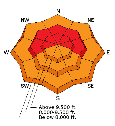
| Advisory: Skyline Area Mountains | Issued by Brett Kobernik for Wednesday - December 23, 2015 - 7:25am |
|---|

|
bottom line The avalanche danger is HIGH today. Wind and new snow has overloaded the weak snow that exists near the ground. Conditions are ripe for an accident. Stay off of and out from underneath any steep slopes. Consider avoiding backcountry travel today.
|
 |
avalanche warning * TIMING...THROUGH 6 AM MST THURSDAY * AFFECTED AREA...ALL THE MOUNTAINS OF NORTHERN AND CENTRAL UTAH AND SOUTHEASTERN IDAHO TO INCLUDE THE WASATCH RANGE, THE BEAR RIVER RANGE, THE WESTERN UINTAS AND THE MANTI-SKYLINE PLATEAU. OTHER MOUNTAIN RANGES WILL LIKELY BE AFFECTED AS WELL * AVALANCHE DANGER...THE AVALANCHE DANGER FOR THE WARNING AREA IS HIGH * IMPACTS...HEAVY SNOWFALL COMBINED WITH STRONG WINDS IS CREATING WIDESPREAD AREAS OF UNSTABLE SNOW. BOTH HUMAN TRIGGERED AND NATURAL AVALANCHES ARE LIKELY AND WILL OCCUR IN MANY AREAS. STAY OFF OF AND OUT FROM UNDER SLOPES STEEPER THAN 30 DEGREES. |
 |
recent activity A natural avalanche cycle occurred on Tuesday. We don't have much info on the extent of it yet. All you need to know is that things are very dangerous out there right now. Here's a couple videos showing what's been going on over the last 24 hours: 20151222 Skyline Huntington Cyn from Brett Kobernik on Vimeo. |
 |
weather |
| general announcements We will publish full detailed advisories Saturday and Sunday mornings by 7am. We will also be publishing basic avalanche danger ratings & info during the week. If you are getting out into the mountains, we love to hear from you! You can SUBMIT OBSERVATIONS ONLINE or EMAIL US If you would like to have avalanche advisories emailed to you, SIGN UP HERE We can provide basic avalanche awareness presentations for your school, group or club. To enquire, CLICK HERE |


