| Please join us at the 23rd annual Black Diamond Fall Fundraiser Party Thursday Sept 15. Tickets are on sale now here, at the Black Diamond store & at REI. Special bonus raffle for online ticket purchasers! |
| Please join us at the 23rd annual Black Diamond Fall Fundraiser Party Thursday Sept 15. Tickets are on sale now here, at the Black Diamond store & at REI. Special bonus raffle for online ticket purchasers! |
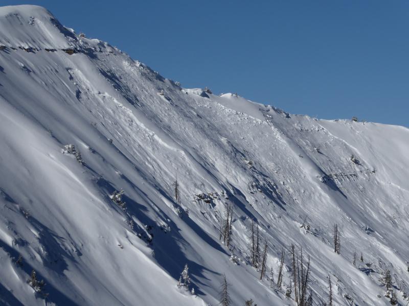
| Advisory: Skyline Area Mountains | Issued by Brett Kobernik for Saturday - December 19, 2015 - 6:45am |
|---|


|
bottom line The avalanche danger is CONSIDERABLE on the upper elevation terrain that faces northwest through east. Human triggered avalanches are likely in these areas. Watch for an increase in southwest wind speeds which may start to drift snow later today.
|
 |
current conditions Temperatures are quite mild in the high country right now. We've seen a steady rise in temperatures over the last 48 hours and most of the highest stations are in the upper 20s. Wind speeds are fairly light from the south. We've had 2 to 3 feet of snow fall over the last week. Most of the high elevation Snotel weather stations are reading around 30 inches of total snow depth. It is deeper in many of the favored locations. |
 |
recent activity There was a natural avalanche cycle early Thursday morning where 5 or 6 inches of new snow fell combined with strong northwest winds. This was enough to finally overload the buried weak snow that is near the ground. These avalanches were 3 to 4 feet deep and some of them up to 400 feet wide. Below is a list of slopes that avalanched. There are surely more that we haven't seen.
My partner and I came across this avalanche in the Big Horseshoe during field work on Friday. It likely released early Thursday morning.
|
| type | aspect/elevation | characteristics |
|---|

|

|
LIKELIHOOD
 LIKELY
UNLIKELY
SIZE
 LARGE
SMALL
TREND
 INCREASING DANGER
SAME
DECREASING DANGER
|
|
description
Triggering an avalanche that breaks into old weak sugary snow near the ground remains the biggest concern for today. This problem may be enhanced later today as southwest wind speeds increase which may drift more snow onto already touchy slopes. |
 |
weather It looks like another beautiful day today with mostly clear skies and temperatures into the low 30s along the peaks. Southwest winds will increase as the day goes on but they don't look like they'll get too awfully strong. Numerous storms will start to impact the area tonight and last through next week. We might see a few inches of new snow by mid day Sunday. The next decent looking storm is scheduled for Tuesday. |
| general announcements We will publish full detailed advisories Saturday and Sunday mornings by 7am. We will also be publishing basic avalanche danger ratings & info during the week. If you are getting out into the mountains, we love to hear from you! You can SUBMIT OBSERVATIONS ONLINE or EMAIL US If you would like to have avalanche advisories emailed to you, SIGN UP HERE We can provide basic avalanche awareness presentations for your school, group or club. To enquire, CLICK HERE |