| Please join us at the 23rd annual Black Diamond Fall Fundraiser Party Thursday Sept 15. Tickets are on sale now here, at the Black Diamond store & at REI. Special bonus raffle for online ticket purchasers! |
| Please join us at the 23rd annual Black Diamond Fall Fundraiser Party Thursday Sept 15. Tickets are on sale now here, at the Black Diamond store & at REI. Special bonus raffle for online ticket purchasers! |
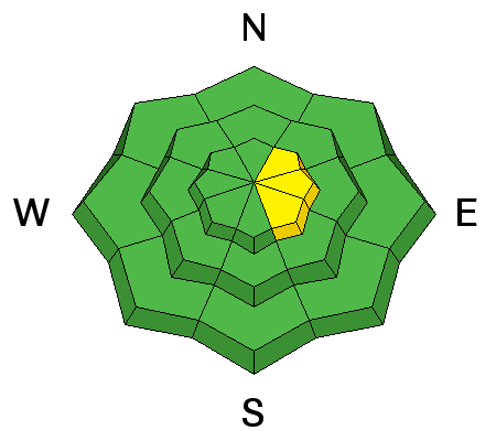
| Advisory: Skyline Area Mountains | Issued by Brett Kobernik for Sunday - December 6, 2015 - 7:58am |
|---|


|
bottom line The majority of the mountain terrain has a LOW avalanche danger. There is a very isolated MODERATE avalanche danger along the highest more east facing slopes where the recent wind has formed fresh drifts which could be triggered by a person.
|
 |
current conditions Ridgetop temperatures are in the mid 20s this morning. Wind speeds are light from the southwest. |
 |
recent activity The wind formed some fresh drifts on Thursday and Friday. They would crack out if provoked, however, they were very small in size. |
| type | aspect/elevation | characteristics |
|---|

|
|
LIKELIHOOD
 LIKELY
UNLIKELY
SIZE
 LARGE
SMALL
TREND
 INCREASING DANGER
SAME
DECREASING DANGER
|
|
description
You might still be able to trigger a recent wind drift today. The recent fresh wind drifts will become less sensitive as time goes on. Again, they are pretty small and don't pose much threat unless you were to get pushed into rocks, stumps or trees. |
 |
weather We'll have fairly fairly nice weather for today and into the first half of the weak. Weather models are still showing a progressive pattern with a number of storms that will start to move through late in the week and into next week. As of now, they look promising for snow. STATE WEATHER SYNOPSIS...A SERIES OF WEAK WEATHER DISTURBANCES WILL GRAZE NORTHERN UTAH AND SOUTHWEST WYOMING THROUGH WEDNESDAY NIGHT. STRONGER AND COLDER STORMS WILL CROSS THE REGION LATE IN THE WEEK THROUGH THE WEEKEND. |
| general announcements We will publish full detailed advisories Saturday and Sunday mornings by 7am. We will also be publishing basic avalanche danger ratings & info during the week. If you are getting out into the mountains, we love to hear from you! You can SUBMIT OBSERVATIONS ONLINE or EMAIL US If you would like to have avalanche advisories emailed to you, SIGN UP HERE We can provide basic avalanche awareness presentations for your school, group or club. To enquire, CLICK HERE |


