| During the month of April, Mark Miller will donate $75 to the charity of your choice (5 to chose from, including the Utah Avalanche Center!) Mark Miller Subaru has raised over $300k in the previous 6 Do Good Feel Good events. More Info here |  |
| During the month of April, Mark Miller will donate $75 to the charity of your choice (5 to chose from, including the Utah Avalanche Center!) Mark Miller Subaru has raised over $300k in the previous 6 Do Good Feel Good events. More Info here | |
| Advisory: Skyline Area Mountains | Issued by Brett Kobernik for Saturday - March 7, 2015 - 5:39am |
|---|

|
bottom line Dangerous avalanche conditions exist in the upper elevation more northerly terrain where large avalanches are likely to be triggered by people. Avoid the higher more northerly facing terrain. Some east facing slopes are suspect as well. Wet avalanche activity may also happen today with the sun heating the new snow on the sunny aspects. Get off of steep slopes as they become wet and don't linger below steep slopes or in gullies.
|
 |
current conditions The new snow from early in the week is settling and travel is becoming easier but dangerous avalanche conditions exist especially on the northerly facing slopes. You'll find heat crusts on the sunny slopes this morning with good powder still on the more northerly terrain. This powder is going to act as a lure into dangerous avalanche terrain. Temperatures warmed significantly on Friday and are about 5 degrees warmer this morning compared to yesterday morning. We have an east flow this morning with light to moderate wind speeds. |
 |
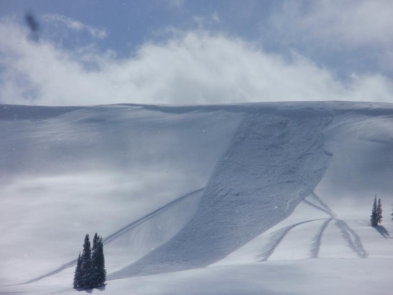
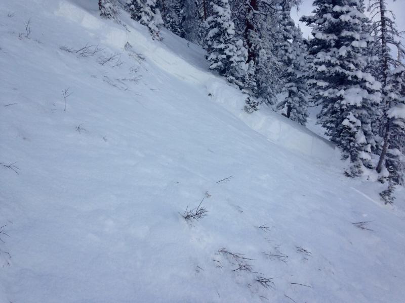
recent activity No new avalanches were reported on Friday but there were numerous naturals during the storm and a handful of human triggered avalanches mid week.
This slide was most likely snowmobile triggered This was a skier triggered avalanche breaking into old facets |
| type | aspect/elevation | characteristics |
|---|

|

|
LIKELIHOOD
 LIKELY
UNLIKELY
SIZE
 LARGE
SMALL
TREND
 INCREASING DANGER
SAME
DECREASING DANGER
|
|
description
By far, the most dangerous situation is in the upper elevation northerly facing terrain where old weak snow is now capped off with 2 to 3 feet of new snow. Human triggered avalanches will be likely through this weekend in the higher terrain. Slopes that avalanched in December are especially suspect as they have a VERY shallow and weak snowpack. This is a dangerous situation because people can travel on a lot of different slopes without triggering anything or seeing any obvious signs of instability. This may give people a false sense of security and then decide to get onto more northerly facing terrain. Make no mistake that this a bad deal. We continued to experience numerous large collapses on Friday which is a tell-tale sign that the underlying weak layer is still active. Here's a great video which describes how the persistent weak layer of "sugary" faceted snow works: Persistent Slab Avalanches from Trent Meisenheimer on Vimeo. |
| type | aspect/elevation | characteristics |
|---|

|

|
LIKELIHOOD
 LIKELY
UNLIKELY
SIZE
 LARGE
SMALL
TREND
INCREASING DANGER
SAME
DECREASING DANGER
|
|
description
Wet avalanche activity is a bit hard to predict just when it will start to happen naturally. Since the new snow has gone through a couple of melt freeze cycles over the last few days during the gradual warm up, this makes me think things won't get out of hand today. However, there is a lot of new snow and if it becomes unstable the wet avalanches could pack a punch. Just be aware that things could heat up enough today to become dangerous. Continue to re-evaluate the snow conditions watching for very wet snow on sunny slopes. Stay out of steep gullies especially those that have big steep slopes above them. |
 |
weather Today will be just slightly warmer than Friday with ridgetop highs in the mid 30s to near 40. The east winds will shift around to the northwest and slow a bit. We'll see mostly clear skies. Sunday looks similar with temperatures just a little lower. No new storms are in sight. The same ridge of high pressure that has dominated this winter moves back in through the foreseen future. |
| general announcements Donate to your favorite non-profit –The Utah Avalanche Center. The UAC depends on contributions from users like you to support our work. Benefit the Utah Avalanche Center when you buy or sell on ebay - set the Utah Avalanche Center as a favorite non-profit in your ebay account here and click on ebay gives when you buy or sell. You can choose to have your seller fees donated to the UAC, which doesn't cost you a penny. Utah Avalanche Center mobile app - Get your advisory on your iPhone along with great navigation and rescue tools. The information in this advisory is from the US Forest Service which is solely responsible for its content. This advisory describes general avalanche conditions and local variations always occur. This advisory will be updated by 7:00 AM Saturday, March 7, 2015 or sooner if conditions warrant. |


.jpg)