| During the month of April, Mark Miller will donate $75 to the charity of your choice (5 to chose from, including the Utah Avalanche Center!) Mark Miller Subaru has raised over $300k in the previous 6 Do Good Feel Good events. More Info here |  |
| During the month of April, Mark Miller will donate $75 to the charity of your choice (5 to chose from, including the Utah Avalanche Center!) Mark Miller Subaru has raised over $300k in the previous 6 Do Good Feel Good events. More Info here | |
| Advisory: Skyline Area Mountains | Issued by Brett Kobernik for Saturday - February 7, 2015 - 7:00am |
|---|

|
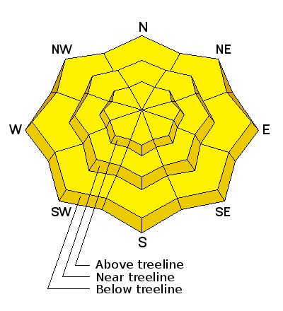
bottom line There is a MODERATE danger for wet avalanche activity today. Keep your eyes out for any avalanches you might see giving you an indicator that the snowpack is becoming unstable. Don't linger in the bottoms of gullies and avalanche paths and pay attention to what is above you.
|
 |
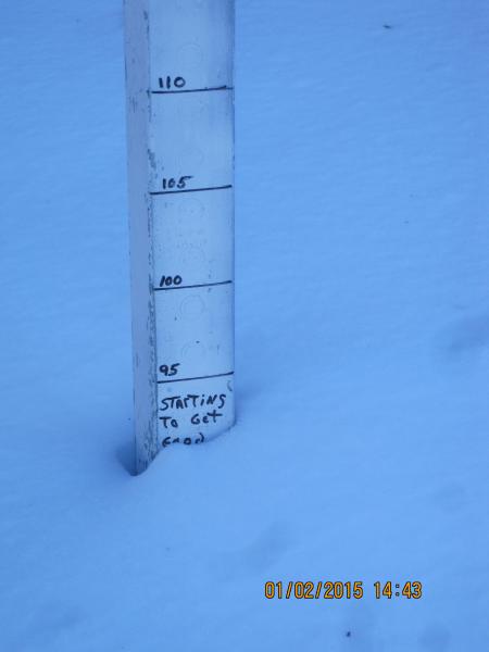
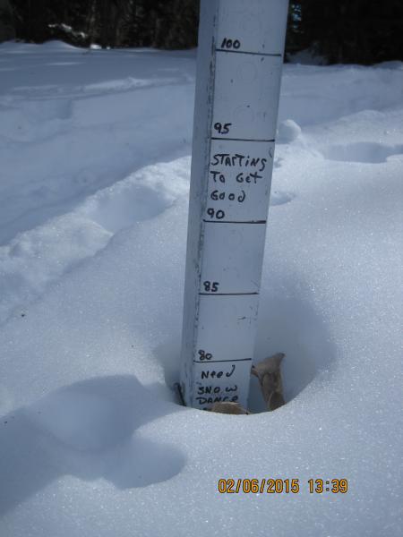
current conditions Unusually warm weather is the headline from this past week. Many upper elevation weather station recorded temperatures of near 50 degrees over the last two days. Most stations remain in the mid 30s currently. Southwest winds have increased and are gusting to near 30mph. Sun crusts and wind crusts are abundant. The snowpack is actually shrinking even in the higher terrain. Check out Darce Trotter's photos of the snow stake (read in centimeters) at Miller Flat and note the dates on them:
|
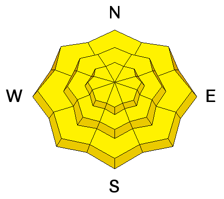
| type | aspect/elevation | characteristics |
|---|

|
|
LIKELIHOOD
 LIKELY
UNLIKELY
SIZE
 LARGE
SMALL
TREND
 INCREASING DANGER
SAME
DECREASING DANGER
|
|
description
The avalanche danger has been pretty LOW for quite a while now. There are a few things that have raised my eyebrows though, namely the continued warm temperatures. One of the indicators for wet avalanche activity that we look for is any period with temperatures above freezing for three consecutive days. This has been the case especially in the mid elevations the last few days. Another indicator is a loss of "snow water equivalent" at the Snotel stations. This is basically showing that the snowpack is melting and thus, water is flowing through it. When water flows through, it can weaken layers and cause avalanche activity. A number of stations showed a loss in "snow water equivalent" on Friday. Breaking this all down, wet avalanche activity is hard to predict but there are a number of indicators that are present which point to possible wet activity. |
 |
weather Temperatures today are going to remain pretty mild once again with highs near 40 along the upper ridges. A minor disturbance is clipping northern Utah and will produce clouds with a very minor chance of a snow shower this morning along the Manti Skyline. We'll probably see some breaks in the clouds later. It looks like it'll be a bit breezy with gusts near 40 along the higher ridges. We'll see partly cloudy skies on Sunday with ridgetop highs again near 40. Winds will slow down on Sunday. The long term looks bleak for any significant new snow. There's a minor disturbance that'll move through early in the week but it won't add much snow if any at all. |
| general announcements Donate to your favorite non-profit –The Utah Avalanche Center. The UAC depends on contributions from users like you to support our work. Benefit the Utah Avalanche Center when you buy or sell on ebay - set the Utah Avalanche Center as a favorite non-profit in your ebay account here and click on ebay gives when you buy or sell. You can choose to have your seller fees donated to the UAC, which doesn't cost you a penny. Utah Avalanche Center mobile app - Get your advisory on your iPhone along with great navigation and rescue tools. The information in this advisory is from the US Forest Service which is solely responsible for its content. This advisory describes general avalanche conditions and local variations always occur. This advisory will be updated by 7:00 AM Saturday, February 14, 2015 or sooner if conditions warrant. |


.jpg)