| During the month of April, Mark Miller will donate $75 to the charity of your choice (5 to chose from, including the Utah Avalanche Center!) Mark Miller Subaru has raised over $300k in the previous 6 Do Good Feel Good events. More Info here |  |
| During the month of April, Mark Miller will donate $75 to the charity of your choice (5 to chose from, including the Utah Avalanche Center!) Mark Miller Subaru has raised over $300k in the previous 6 Do Good Feel Good events. More Info here | |
| Advisory: Skyline Area Mountains | Issued by Brett Kobernik for Saturday - January 24, 2015 - 6:59am |
|---|

|
bottom line The avalanche danger will be mostly LOW over the weekend. Wind slabs can be triggered along the very steep more east facing slopes. Keep in mind the consequences of even a small avalanche if you are in steep, radical terrain.
|
 |
special announcement We will be hosting an avalanche class for snowmobilers at the end of the month. We will do presentations on avalanche safety Friday, January 30, 6 to 9pm at Big Pine Sports. We will be out in the mountains for hands on learning Saturday, January 31. Sign up HERE. |
 |
current conditions We've had moderate speed west winds along the ridges over the last week. Temperatures got cold mid week and are starting to rebound. Most mountain stations are in the low to mid 20s this morning. Northerly winds look fairly light this morning. The snow surface varies greatly from place to place as we haven't seen any significant snow since January 12th. You'll find wind crusts and sun crusts on the majority of the terrain. You will, however, still find nice soft snow if you hunt around. Here are a few recent observations:
|
 |
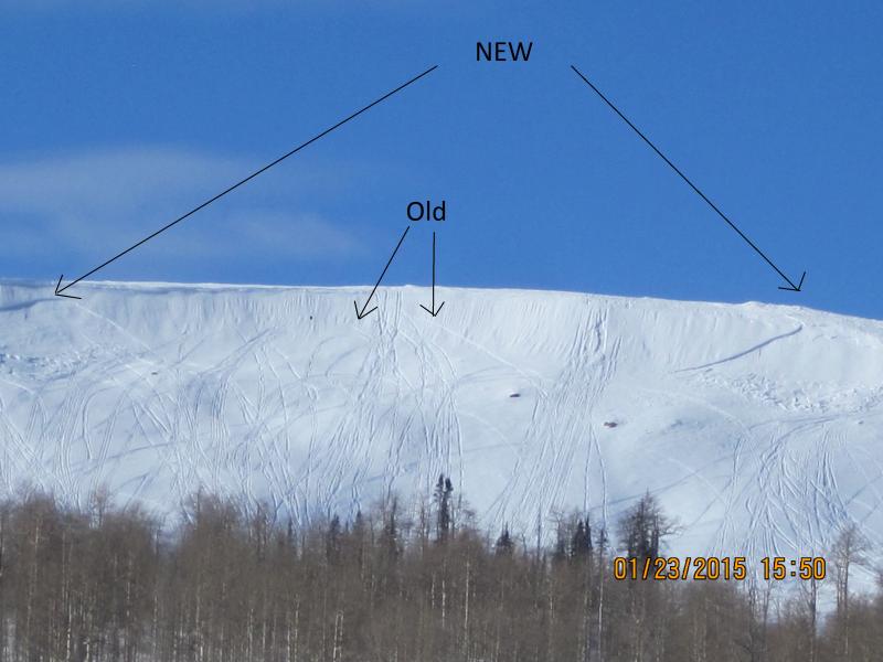
recent activity There were a couple of wind slabs that released on Wedding Ring Ridge. These were formed from the continued wind that we've seen over the last week which drifted snow into these slabs. These were most likely triggered by snowmobilers. These are quite typical for this area.
|
| type | aspect/elevation | characteristics |
|---|

|
|
LIKELIHOOD
 LIKELY
UNLIKELY
SIZE
 LARGE
SMALL
TREND
 INCREASING DANGER
SAME
DECREASING DANGER
|
|
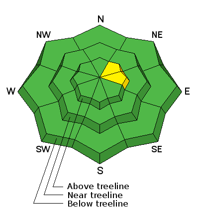
description
We have been enjoying relatively safe avalanche conditions in the mountains over the last week. With nice weather in store for the weekend, avalanche conditions will continue to be pretty safe. |
| type | aspect/elevation | characteristics |
|---|

|
|
LIKELIHOOD
LIKELY
UNLIKELY
SIZE
 LARGE
SMALL
TREND
 INCREASING DANGER
SAME
DECREASING DANGER
|
|
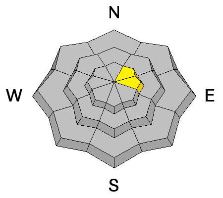
description
On the steepest more east facing slopes, you may be able to find a wind slab that could release. These won't be huge but perhaps big enough to knock you off your sled. If you are in terrain where you'll be carried into rocks or trees or pushed off a cliff if you get caught by a small wind slab, consider those consequences. |
 |
weather We'll have mostly clear skies today with ridgetop highs around freezing. Northerly winds will be in the light to moderate speed range. We should see more clear skies on Sunday but with warmer temperatures by about 10 degrees with just slightly more gusty wind. Monday will be the warmest day as the ridge of high pressure will be directly over us. We are watching a "closed low" which may push a storm through Tuesday from the southwest. Currently it looks like it weakens as it makes it's way inland. However, it may produce enough snow accumulations to give us a "refresher". It looks as if the blocking pattern with the same ridge of high pressure will move back in later in the week. |
| general announcements Donate to your favorite non-profit –The Utah Avalanche Center. The UAC depends on contributions from users like you to support our work. Benefit the Utah Avalanche Center when you buy or sell on ebay - set the Utah Avalanche Center as a favorite non-profit in your ebay account here and click on ebay gives when you buy or sell. You can choose to have your seller fees donated to the UAC, which doesn't cost you a penny. Utah Avalanche Center mobile app - Get your advisory on your iPhone along with great navigation and rescue tools. The information in this advisory is from the US Forest Service which is solely responsible for its content. This advisory describes general avalanche conditions and local variations always occur. This advisory will be updated by 7:00 AM Saturday, January 31, 2015 or sooner if conditions warrant. |


.jpg)