| During the month of April, Mark Miller will donate $75 to the charity of your choice (5 to chose from, including the Utah Avalanche Center!) Mark Miller Subaru has raised over $300k in the previous 6 Do Good Feel Good events. More Info here |  |
| During the month of April, Mark Miller will donate $75 to the charity of your choice (5 to chose from, including the Utah Avalanche Center!) Mark Miller Subaru has raised over $300k in the previous 6 Do Good Feel Good events. More Info here | |
| Advisory: Skyline Area Mountains | Issued by Craig Gordon for Tuesday - December 23, 2014 - 6:22am |
|---|

|
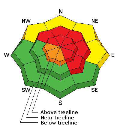
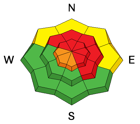
bottom line At mid and upper elevations, at and above treeline, the avalanche danger is HIGH. Human triggered avalanches are likely especially on steep, wind drifted slopes facing the north half of the compass. Any slide triggered today has the potential to break deep and wide, resulting in a dangerous and possibly unsurvivable avalanche. A CONSIDERABLE danger exists on upper elevation south facing terrain and human triggered avalanches are probable. Looking for LOW avalanche danger? Head to low elevation south facing slopes that have no preexisting weak snow issues or big open meadows with no steep slopes above or adjacent to where you're riding.
|
 |
avalanche warning AN AVALANCHE WARNING CONTINUES FOR THE MANTI SKYLINE. RECENT HEAVY SNOW AND STRONG WINDS HAVE CREATED A HIGH AVALANCHE DANGER. HUMAN TRIGGERED AVALANCHES ARE LIKELY TODAY ON TERRAIN STEEPER THAN 30 DEGREES ABOVE 8000 FEET. PEOPLE SHOULD AVOID BEING ON OR BELOW ANY STEEP SNOW COVERED SLOPES UNTIL AVALANCHE CONDITIONS IMPROVE. THIS WARNING DOES NOT INCLUDE SKI AREAS OR HIGHWAYS WHERE AVALANCHE CONTROL IS NORMALLY DONE. |
 |
special announcement
Huge thanks to Sam T Evans and Look Trailers for generously donating a loaner two place sled trailer for the 2014-15 season.... y'all rock! We just released an exciting, new avy safety video designed specifically for snowmobilers - Knowledge is Powder. https://vimeo.com/113677686 NEW THIS YEAR: You can now receive advisories by email for each region in the state. Go here for details.
|
 |
current conditions Skies are clear and a couple inches of light density snow fell late yesterday bringing storm totals close to two feet. Temperatures are in the low teen's and winds have mellowed out somewhat and are blowing 10-20 mph along the summit. The Skyline snowpack went from zero to hero in the past 48 hours and coverage has vastly improved.
|
 |
recent activity Visibility was extremely limited yesterday and no recent avalanche activity was reported.
|
| type | aspect/elevation | characteristics |
|---|

|
|
LIKELIHOOD
 LIKELY
UNLIKELY
SIZE
 LARGE
SMALL
TREND
 INCREASING DANGER
SAME
DECREASING DANGER
|
|
description
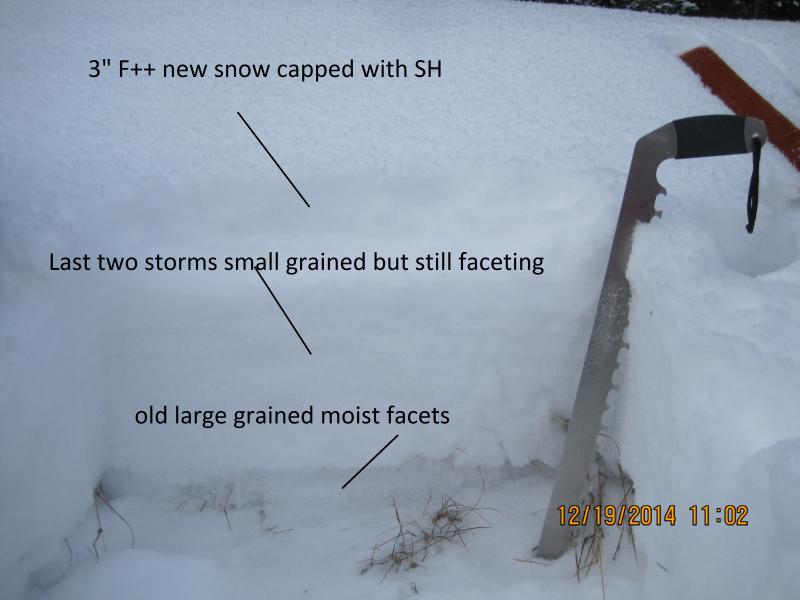
This was a great storm for the Skyline, but we've gotta remember all the heavy snow, lots of water weight, and hurricane force winds all slammed down on a weak, sugary snowpack. We've got a deceptively dangerous setup because the snow will feel strong and bomber underneath our skis, board, or sled. So here's the deal... we need to think not only about the snow we're riding in, but also the snow we're riding on and right now the weak pre-exisitng snow needs some time to adjust. It doesn't mean you can't ride.... it does mean you're gonna have to avoid being on or under steep, wind drifted slopes, especially those facing the north half of the compass. Any avalanche triggered today has the potential to break into weak layers near the ground, producing a large and dangerous slide. Add sunny skies to the mix and now we've got the perfect setup for a close call, or worse yet, avalanche accident. Remember- whoomphing sounds or shooting cracks in front of your skis, board, or sled are huge clues to unstable snow. And don't forget the biggest clue... recent avalanches! Especially if they're occurring on the same kind of slope you wanna ride on.
The weak and sugary surface snow is no match for the big weekend storm. Steve, Darce, and Cody were out stomping around Friday and their great insight on the conditions can be found here. |
 |
weather High pressure builds over the region, giving us mostly sunny skies with temperatures warming into the low and mid 20's. Winds should remain relatively well behaved and in the 15-25 mph range along the ridges. Clear skies lead to overnight lows in the teens. Increasing clouds Wednesday with a significant winter storm on tap for late Wednesday night, continuing through Friday. Looks like a foot of snow is a good bet when the storm winds down on Saturday.
|
| general announcements We're still interested in snow and avalanche information. If you see anything we should know about, please participate in the creation of our own community avalanche advisory by submitting snow and avalanche conditions. You can call me directly at 801-231-2170, email [email protected], or email by clicking HERE Donate to your favorite non-profit –The Utah Avalanche Center. The UAC depends on contributions from users like you to support our work. Benefit the Utah Avalanche Center when you buy or sell on ebay - set the Utah Avalanche Center as a favorite non-profit in your ebay account here and click on ebay gives when you buy or sell. You can choose to have your seller fees donated to the UAC, which doesn't cost you a penny. Utah Avalanche Center mobile app - Get your advisory on your iPhone along with great navigation and rescue tools. The information in this advisory is from the US Forest Service which is solely responsible for its content. This advisory describes general avalanche conditions and local variations always occur. I will update this advisory by 7:00 AM Wednesday Dec. 24, 2014. |


.jpg)