| During the month of April, Mark Miller will donate $75 to the charity of your choice (5 to chose from, including the Utah Avalanche Center!) Mark Miller Subaru has raised over $300k in the previous 6 Do Good Feel Good events. More Info here |  |
| During the month of April, Mark Miller will donate $75 to the charity of your choice (5 to chose from, including the Utah Avalanche Center!) Mark Miller Subaru has raised over $300k in the previous 6 Do Good Feel Good events. More Info here | |
| Advisory: Skyline Area Mountains | Issued by Craig Gordon for Monday - December 22, 2014 - 6:41am |
|---|


|
bottom line At mid and upper elevations, at and above treeline, the avalanche danger is HIGH. Human triggered avalanches are likely especially on steep, wind drifted slopes facing the north half of the compass. Any slide triggered today has the potential to break deep and wide, resulting in a dangerous and possibly unsurvivable avalanche. A CONSIDERABLE danger exists on upper elevation south facing terrain and human triggered avalanches are probable. Looking for LOW avalanche danger? Head to low elevation south facing slopes that have no preexisting weak snow issues or big open meadows with no steep slopes above or adjacent to where you're ridng.
|
 |
avalanche warning THIS AVALANCHE WARNING IS FOR THE WASATCH...BEAR RIVER AND WESTERN UINTA MOUNTAIN RANGES...THE WASATCH PLATEAU AND THE CENTRAL UTAH MOUNTAINS. HEAVY SNOW AND STRONG WINDS HAVE CREATED A HIGH AVALANCHE DANGER. HUMAN TRIGGERED AND NATURAL AVALANCHES CONTINUE TO BE LIKELY TODAY ON TERRAIN STEEPER THAN 30 DEGREES ABOVE 8000 FEET. PEOPLE SHOULD AVOID BEING ON OR BELOW ANY STEEP SNOW COVERED SLOPES UNTIL AVALANCHE CONDITIONS IMPROVE. THIS WARNING DOES NOT INCLUDE SKI AREAS OR HIGHWAYS WHERE AVALANCHE CONTROL IS NORMALLY DONE. |
 |
special announcement
Huge thanks to Sam T Evans and Look Trailers for generously donating a loaner two place sled trailer for the 2014-15 season.... y'all rock! We just released an exciting, new avy safety video designed specifically for snowmobilers - Knowledge is Powder. https://vimeo.com/113677686 NEW THIS YEAR: You can now receive advisories by email for each region in the state. Go here for details.
|
 |
current conditions Wow... the Skyline got slammed! A much needed 12"-18" of dense, heavy snow blanketed the region yesterday along with nuking ridgetop winds. The storm has dried out somewhat and light snow is still falling this morning. Temperatures are in the upper 20's and winds have mellowed out and are light and variable along the summit. The snow is upside down and riding and turning conditions are gonna be a bit funky today.
|
 |
recent activity Visibilty was extremely limited yesterday and no recent avalanche activity was reported.
|
| type | aspect/elevation | characteristics |
|---|

|

|
LIKELIHOOD
 LIKELY
UNLIKELY
SIZE
 LARGE
SMALL
TREND
 INCREASING DANGER
SAME
DECREASING DANGER
|
|
description
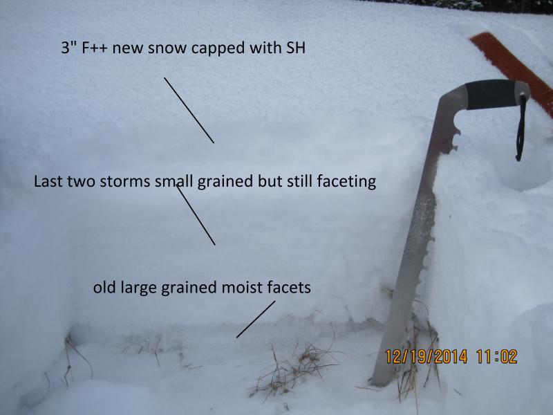
Sunday's big storm delivered a one-two punch to the Skyline with dense, heavy, water laden snow and raging winds. All of that weight slammed down onto a preexisting weak, layer of sugary snow... yup, we've got the classic strong snow on weak snow combo. You don't need to be a rocket scientist or a snow scientist for that matter to realize it's sketchy in the mountains and you don't have to be on steep, radical terrain to trigger an avalanche. As a matter of fact, you'll be able to trigger slides from a distance and on relatively low angle terrain. Once initiated, today's slides will break deep and wide and have the potential to take out the entire seasons snowpack. It doesn't mean you can't ride.... it does mean you're gonna have to avoid being on or under steep, wind drifted slopes, especially those facing the north half of the compass. Remember- whoomphing sounds or shooting cracks in front of your skis, board, or sled are huge clues to unstable snow. And don't forget the biggest clue... recent avalanches! Especially if they're occurring on the same kind of slope you wanna ride on.
The weak and sugary surface snow is no match for the big weekend storm. Steve, Darce, and Cody were out stomping around Friday and their great insight on the conditions can be found here. |
 |
weather It's gonna be another rugged day in the mountains as the very strong and moist northwest flow continues. Look for periods of snow with an additional 2"-4" throughout the day. West and northwest winds will blast the high peaks, blowing in the 40's and 50's. Temperatures don't vary much from where we're at this morning and as skies clear tonight temperatures dive into the teens. Clear weather and a warming trend is on tap for Tuesday and Wednesday with another colder storm slated for Christmas day.
|
| general announcements We're still interested in snow and avalanche information. If you see anything we should know about, please participate in the creation of our own community avalanche advisory by submitting snow and avalanche conditions. You can call me directly at 801-231-2170, email [email protected], or email by clicking HERE Donate to your favorite non-profit –The Utah Avalanche Center. The UAC depends on contributions from users like you to support our work. Benefit the Utah Avalanche Center when you buy or sell on ebay - set the Utah Avalanche Center as a favorite non-profit in your ebay account here and click on ebay gives when you buy or sell. You can choose to have your seller fees donated to the UAC, which doesn't cost you a penny. Utah Avalanche Center mobile app - Get your advisory on your iPhone along with great navigation and rescue tools. The information in this advisory is from the US Forest Service which is solely responsible for its content. This advisory describes general avalanche conditions and local variations always occur. I will update this advisory by 7:00 AM Tuesday Dec. 23, 2014. |


.jpg)